You are here: Home > Network List > GS - US Geological Survey Networks Stations List
> Station OK027 Henny and Sorgum Hills Rd. > Earthquake Result Viewer
OK027 Henny and Sorgum Hills Rd. - Earthquake Result Viewer
| Earthquake location: |
Central Peru |
| Earthquake latitude/longitude: |
-14.6/-73.6 |
| Earthquake time(UTC): |
2014/08/24 (236) 23:21:45 GMT |
| Earthquake Depth: |
101 km |
| Earthquake Magnitude: |
6.9 MWW, 6.8 MI, 6.9 MWB |
| Earthquake Catalog/Contributor: |
NEIC PDE/NEIC COMCAT |
|
| Network: |
GS US Geological Survey Networks |
| Station: |
OK027 Henny and Sorgum Hills Rd. |
| Lat/Lon: |
35.71 N/97.28 W |
| Elevation: |
364 m |
|
| Distance: |
54.8 deg |
| Az: |
336.406 deg |
| Baz: |
151.564 deg |
| Ray Param: |
0.06488162 |
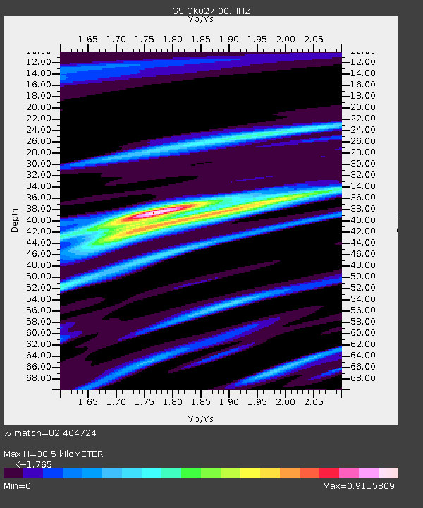
| Estimated Moho Depth: |
38.5 km |
| Estimated Crust Vp/Vs: |
1.76 |
| Assumed Crust Vp: |
6.426 km/s |
| Estimated Crust Vs: |
3.641 km/s |
| Estimated Crust Poisson's Ratio: |
0.26 |
|
| Radial Match: |
82.404724 % |
| Radial Bump: |
400 |
| Transverse Match: |
78.07243 % |
| Transverse Bump: |
400 |
| SOD ConfigId: |
769524 |
| Insert Time: |
2014-09-07 23:42:56.741 +0000 |
| GWidth: |
2.5 |
| Max Bumps: |
400 |
| Tol: |
0.001 |
|

Signal To Noise
| Channel | StoN | STA | LTA |
| GS:OK027:00:HHZ:20140824T23:30:35.039021Z | 43.473736 | 8.603175E-6 | 1.9789363E-7 |
| GS:OK027:00:HH1:20140824T23:30:35.039021Z | 17.993814 | 4.7443464E-6 | 2.636654E-7 |
| GS:OK027:00:HH2:20140824T23:30:35.039021Z | 14.63857 | 3.068762E-6 | 2.0963537E-7 |
| Arrivals |
| Ps | 4.8 SECOND |
| PpPs | 16 SECOND |
| PsPs/PpSs | 21 SECOND |


