You are here: Home > Network List > GS - US Geological Survey Networks Stations List
> Station ID04 Mogan Creek Rd (Rte 129), ID, USA > Earthquake Result Viewer
ID04 Mogan Creek Rd (Rte 129), ID, USA - Earthquake Result Viewer
| Earthquake location: |
Central Peru |
| Earthquake latitude/longitude: |
-14.6/-73.6 |
| Earthquake time(UTC): |
2014/08/24 (236) 23:21:45 GMT |
| Earthquake Depth: |
101 km |
| Earthquake Magnitude: |
6.9 MWW, 6.8 MI, 6.9 MWB |
| Earthquake Catalog/Contributor: |
NEIC PDE/NEIC COMCAT |
|
| Network: |
GS US Geological Survey Networks |
| Station: |
ID04 Mogan Creek Rd (Rte 129), ID, USA |
| Lat/Lon: |
44.85 N/114.24 W |
| Elevation: |
2500 m |
|
| Distance: |
69.7 deg |
| Az: |
330.384 deg |
| Baz: |
137.734 deg |
| Ray Param: |
0.055201612 |
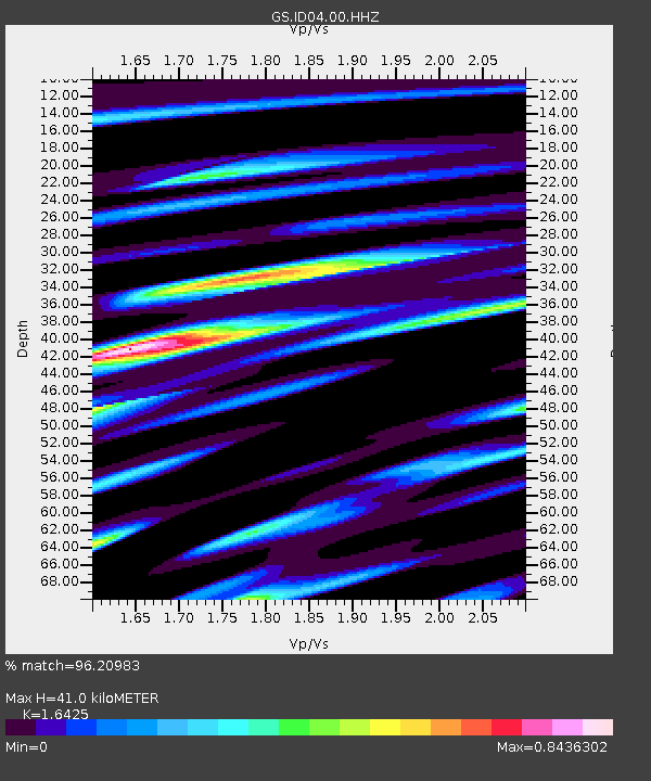
| Estimated Moho Depth: |
41.0 km |
| Estimated Crust Vp/Vs: |
1.64 |
| Assumed Crust Vp: |
6.577 km/s |
| Estimated Crust Vs: |
4.004 km/s |
| Estimated Crust Poisson's Ratio: |
0.21 |
|
| Radial Match: |
96.20983 % |
| Radial Bump: |
400 |
| Transverse Match: |
78.859406 % |
| Transverse Bump: |
400 |
| SOD ConfigId: |
769524 |
| Insert Time: |
2014-09-07 23:43:11.905 +0000 |
| GWidth: |
2.5 |
| Max Bumps: |
400 |
| Tol: |
0.001 |
|

Signal To Noise
| Channel | StoN | STA | LTA |
| GS:ID04:00:HHZ:20140824T23:32:14.159016Z | 73.34316 | 7.046147E-6 | 9.607095E-8 |
| GS:ID04:00:HH1:20140824T23:32:14.159016Z | 25.70447 | 2.3609973E-6 | 9.1851625E-8 |
| GS:ID04:00:HH2:20140824T23:32:14.159016Z | 17.826544 | 2.0247385E-6 | 1.1357998E-7 |
| Arrivals |
| Ps | 4.2 SECOND |
| PpPs | 16 SECOND |
| PsPs/PpSs | 20 SECOND |


