You are here: Home > Network List > IU - Global Seismograph Network (GSN - IRIS/USGS) Stations List
> Station TEIG Tepich, Yucatan, Mexico > Earthquake Result Viewer
TEIG Tepich, Yucatan, Mexico - Earthquake Result Viewer
| Earthquake location: |
Central Peru |
| Earthquake latitude/longitude: |
-14.6/-73.6 |
| Earthquake time(UTC): |
2014/08/24 (236) 23:21:45 GMT |
| Earthquake Depth: |
101 km |
| Earthquake Magnitude: |
6.9 MWW, 6.8 MI, 6.9 MWB |
| Earthquake Catalog/Contributor: |
NEIC PDE/NEIC COMCAT |
|
| Network: |
IU Global Seismograph Network (GSN - IRIS/USGS) |
| Station: |
TEIG Tepich, Yucatan, Mexico |
| Lat/Lon: |
20.23 N/88.28 W |
| Elevation: |
40 m |
|
| Distance: |
37.5 deg |
| Az: |
336.953 deg |
| Baz: |
156.196 deg |
| Ray Param: |
0.07576699 |
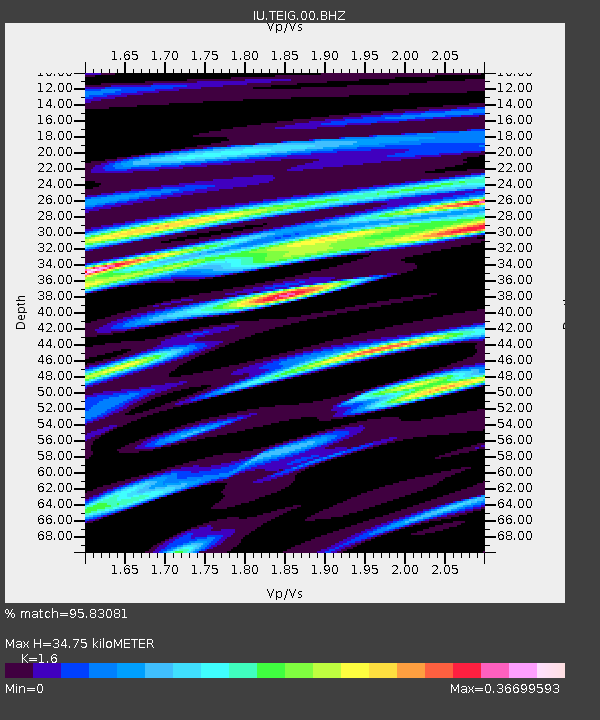
| Estimated Moho Depth: |
34.75 km |
| Estimated Crust Vp/Vs: |
1.60 |
| Assumed Crust Vp: |
5.817 km/s |
| Estimated Crust Vs: |
3.636 km/s |
| Estimated Crust Poisson's Ratio: |
0.18 |
|
| Radial Match: |
95.83081 % |
| Radial Bump: |
364 |
| Transverse Match: |
95.62972 % |
| Transverse Bump: |
364 |
| SOD ConfigId: |
769524 |
| Insert Time: |
2014-09-07 23:45:35.517 +0000 |
| GWidth: |
2.5 |
| Max Bumps: |
400 |
| Tol: |
0.001 |
|

Signal To Noise
| Channel | StoN | STA | LTA |
| IU:TEIG:00:BHZ:20140824T23:28:19.564015Z | 115.908104 | 1.06443285E-5 | 9.18342E-8 |
| IU:TEIG:00:BH1:20140824T23:28:19.564015Z | 2.47031 | 7.936332E-8 | 3.2126867E-8 |
| IU:TEIG:00:BH2:20140824T23:28:19.564015Z | 56.62937 | 6.28243E-6 | 1.10939425E-7 |
| Arrivals |
| Ps | 3.8 SECOND |
| PpPs | 15 SECOND |
| PsPs/PpSs | 18 SECOND |


