You are here: Home > Network List > II - Global Seismograph Network (GSN - IRIS/IDA) Stations List
> Station ALE Alert, N.W.T., Canada > Earthquake Result Viewer
ALE Alert, N.W.T., Canada - Earthquake Result Viewer
| Earthquake location: |
Luzon, Philippines |
| Earthquake latitude/longitude: |
16.4/121.0 |
| Earthquake time(UTC): |
1990/07/17 (198) 21:14:40 GMT |
| Earthquake Depth: |
7.0 km |
| Earthquake Magnitude: |
6.0 MB, 6.6 MS |
| Earthquake Catalog/Contributor: |
WHDF/NEIC |
|
| Network: |
II Global Seismograph Network (GSN - IRIS/IDA) |
| Station: |
ALE Alert, N.W.T., Canada |
| Lat/Lon: |
82.50 N/62.35 W |
| Elevation: |
60 m |
|
| Distance: |
81.2 deg |
| Az: |
0.448 deg |
| Baz: |
356.724 deg |
| Ray Param: |
0.0477383 |
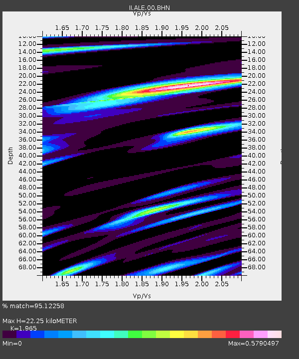
| Estimated Moho Depth: |
22.25 km |
| Estimated Crust Vp/Vs: |
1.97 |
| Assumed Crust Vp: |
6.287 km/s |
| Estimated Crust Vs: |
3.2 km/s |
| Estimated Crust Poisson's Ratio: |
0.33 |
|
| Radial Match: |
95.12258 % |
| Radial Bump: |
400 |
| Transverse Match: |
88.4172 % |
| Transverse Bump: |
400 |
| SOD ConfigId: |
61242 |
| Insert Time: |
2010-03-02 01:05:16.350 +0000 |
| GWidth: |
2.5 |
| Max Bumps: |
400 |
| Tol: |
0.001 |
|

Signal To Noise
| Channel | StoN | STA | LTA |
| II:ALE:00:BHN:19900717T21:26:25.577026Z | 6.6277037 | 1.4765554E-6 | 2.2278537E-7 |
| II:ALE:00:BHE:19900717T21:26:25.578003Z | 0.56341654 | 1.2576201E-7 | 2.2321319E-7 |
| II:ALE:00:BHZ:19900717T21:26:25.578003Z | 17.349524 | 4.1492854E-6 | 2.3915848E-7 |
| Arrivals |
| Ps | 3.5 SECOND |
| PpPs | 10 SECOND |
| PsPs/PpSs | 14 SECOND |


