You are here: Home > Network List > IW - Intermountain West Stations List
> Station MFID Camas Ranch, Mayfield, ID, USA > Earthquake Result Viewer
MFID Camas Ranch, Mayfield, ID, USA - Earthquake Result Viewer
| Earthquake location: |
Central Peru |
| Earthquake latitude/longitude: |
-14.6/-73.6 |
| Earthquake time(UTC): |
2014/08/24 (236) 23:21:45 GMT |
| Earthquake Depth: |
101 km |
| Earthquake Magnitude: |
6.9 MWW, 6.8 MI, 6.9 MWB |
| Earthquake Catalog/Contributor: |
NEIC PDE/NEIC COMCAT |
|
| Network: |
IW Intermountain West |
| Station: |
MFID Camas Ranch, Mayfield, ID, USA |
| Lat/Lon: |
43.42 N/115.83 W |
| Elevation: |
1302 m |
|
| Distance: |
69.5 deg |
| Az: |
328.452 deg |
| Baz: |
135.96 deg |
| Ray Param: |
0.05537487 |
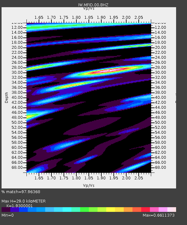
| Estimated Moho Depth: |
29.0 km |
| Estimated Crust Vp/Vs: |
1.93 |
| Assumed Crust Vp: |
6.291 km/s |
| Estimated Crust Vs: |
3.26 km/s |
| Estimated Crust Poisson's Ratio: |
0.32 |
|
| Radial Match: |
97.96368 % |
| Radial Bump: |
316 |
| Transverse Match: |
92.254555 % |
| Transverse Bump: |
400 |
| SOD ConfigId: |
769524 |
| Insert Time: |
2014-09-07 23:45:57.987 +0000 |
| GWidth: |
2.5 |
| Max Bumps: |
400 |
| Tol: |
0.001 |
|

Signal To Noise
| Channel | StoN | STA | LTA |
| IW:MFID:00:BHZ:20140824T23:32:12.550007Z | 79.18588 | 9.3728095E-6 | 1.1836466E-7 |
| IW:MFID:00:BH1:20140824T23:32:12.550007Z | 52.057278 | 2.8411357E-6 | 5.4577107E-8 |
| IW:MFID:00:BH2:20140824T23:32:12.550007Z | 27.690996 | 2.4079152E-6 | 8.695662E-8 |
| Arrivals |
| Ps | 4.4 SECOND |
| PpPs | 13 SECOND |
| PsPs/PpSs | 18 SECOND |


