You are here: Home > Network List > II - Global Seismograph Network (GSN - IRIS/IDA) Stations List
> Station ALE Alert, N.W.T., Canada > Earthquake Result Viewer
ALE Alert, N.W.T., Canada - Earthquake Result Viewer
| Earthquake location: |
Hindu Kush Region, Afghanistan |
| Earthquake latitude/longitude: |
36.1/70.5 |
| Earthquake time(UTC): |
1991/01/31 (031) 23:03:34 GMT |
| Earthquake Depth: |
152 km |
| Earthquake Magnitude: |
6.4 MB, 6.6 UNKNOWN |
| Earthquake Catalog/Contributor: |
WHDF/NEIC |
|
| Network: |
II Global Seismograph Network (GSN - IRIS/IDA) |
| Station: |
ALE Alert, N.W.T., Canada |
| Lat/Lon: |
82.50 N/62.35 W |
| Elevation: |
60 m |
|
| Distance: |
59.4 deg |
| Az: |
353.577 deg |
| Baz: |
43.642 deg |
| Ray Param: |
0.061723795 |
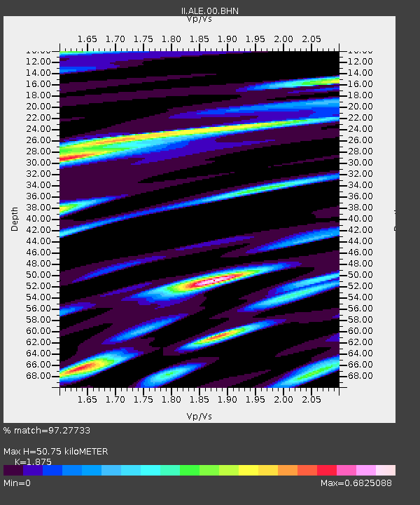
| Estimated Moho Depth: |
50.75 km |
| Estimated Crust Vp/Vs: |
1.88 |
| Assumed Crust Vp: |
6.287 km/s |
| Estimated Crust Vs: |
3.353 km/s |
| Estimated Crust Poisson's Ratio: |
0.30 |
|
| Radial Match: |
97.27733 % |
| Radial Bump: |
400 |
| Transverse Match: |
85.74367 % |
| Transverse Bump: |
400 |
| SOD ConfigId: |
61242 |
| Insert Time: |
2010-03-02 01:05:49.571 +0000 |
| GWidth: |
2.5 |
| Max Bumps: |
400 |
| Tol: |
0.001 |
|

Signal To Noise
| Channel | StoN | STA | LTA |
| II:ALE:00:BHN:19910131T23:12:50.832007Z | 3.0648086 | 4.9593045E-6 | 1.618145E-6 |
| II:ALE:00:BHE:19910131T23:12:50.832007Z | 8.5980215 | 5.523926E-6 | 6.424648E-7 |
| II:ALE:00:BHZ:19910131T23:12:50.832007Z | 8.79467 | 1.5303402E-5 | 1.7400769E-6 |
| Arrivals |
| Ps | 7.4 SECOND |
| PpPs | 22 SECOND |
| PsPs/PpSs | 30 SECOND |


