You are here: Home > Network List > N4 - Central and EAstern US Network Stations List
> Station T42B Van Buren, MO, USA > Earthquake Result Viewer
T42B Van Buren, MO, USA - Earthquake Result Viewer
| Earthquake location: |
Central Peru |
| Earthquake latitude/longitude: |
-14.6/-73.6 |
| Earthquake time(UTC): |
2014/08/24 (236) 23:21:45 GMT |
| Earthquake Depth: |
101 km |
| Earthquake Magnitude: |
6.9 MWW, 6.8 MI, 6.9 MWB |
| Earthquake Catalog/Contributor: |
NEIC PDE/NEIC COMCAT |
|
| Network: |
N4 Central and EAstern US Network |
| Station: |
T42B Van Buren, MO, USA |
| Lat/Lon: |
37.03 N/91.09 W |
| Elevation: |
165 m |
|
| Distance: |
53.9 deg |
| Az: |
342.664 deg |
| Baz: |
158.87 deg |
| Ray Param: |
0.06546782 |
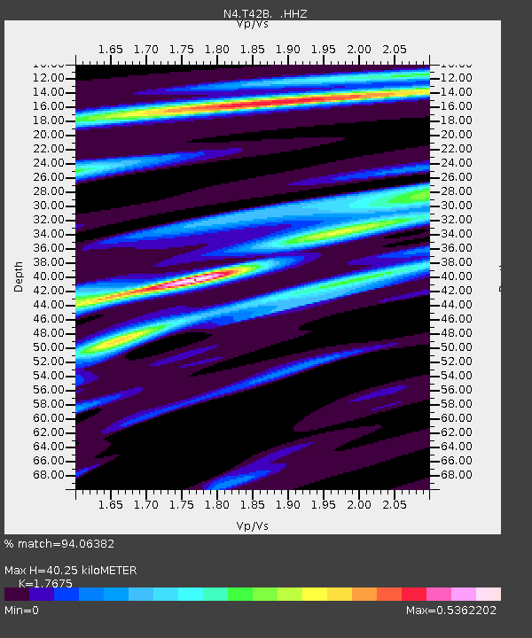
| Estimated Moho Depth: |
40.25 km |
| Estimated Crust Vp/Vs: |
1.77 |
| Assumed Crust Vp: |
6.53 km/s |
| Estimated Crust Vs: |
3.695 km/s |
| Estimated Crust Poisson's Ratio: |
0.26 |
|
| Radial Match: |
94.06382 % |
| Radial Bump: |
209 |
| Transverse Match: |
70.48742 % |
| Transverse Bump: |
336 |
| SOD ConfigId: |
769524 |
| Insert Time: |
2014-09-07 23:50:24.676 +0000 |
| GWidth: |
2.5 |
| Max Bumps: |
400 |
| Tol: |
0.001 |
|

Signal To Noise
| Channel | StoN | STA | LTA |
| N4:T42B: :HHZ:20140824T23:30:28.529988Z | 81.16097 | 6.8728896E-6 | 8.46822E-8 |
| N4:T42B: :HHN:20140824T23:30:28.529988Z | 43.66888 | 2.9075677E-6 | 6.6582146E-8 |
| N4:T42B: :HHE:20140824T23:30:28.529988Z | 25.51868 | 1.4954314E-6 | 5.8601437E-8 |
| Arrivals |
| Ps | 5.0 SECOND |
| PpPs | 16 SECOND |
| PsPs/PpSs | 21 SECOND |


