You are here: Home > Network List > II - Global Seismograph Network (GSN - IRIS/IDA) Stations List
> Station ALE Alert, N.W.T., Canada > Earthquake Result Viewer
ALE Alert, N.W.T., Canada - Earthquake Result Viewer
| Earthquake location: |
Northwestern Caucasus |
| Earthquake latitude/longitude: |
42.5/43.6 |
| Earthquake time(UTC): |
1991/04/29 (119) 09:12:47 GMT |
| Earthquake Depth: |
10 km |
| Earthquake Magnitude: |
6.2 MB, 7.0 MS |
| Earthquake Catalog/Contributor: |
WHDF/NEIC |
|
| Network: |
II Global Seismograph Network (GSN - IRIS/IDA) |
| Station: |
ALE Alert, N.W.T., Canada |
| Lat/Lon: |
82.50 N/62.35 W |
| Elevation: |
60 m |
|
| Distance: |
50.2 deg |
| Az: |
350.539 deg |
| Baz: |
67.779 deg |
| Ray Param: |
0.06822853 |
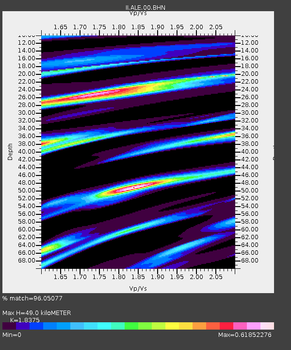
| Estimated Moho Depth: |
49.0 km |
| Estimated Crust Vp/Vs: |
1.84 |
| Assumed Crust Vp: |
6.287 km/s |
| Estimated Crust Vs: |
3.422 km/s |
| Estimated Crust Poisson's Ratio: |
0.29 |
|
| Radial Match: |
96.05077 % |
| Radial Bump: |
286 |
| Transverse Match: |
85.40764 % |
| Transverse Bump: |
400 |
| SOD ConfigId: |
61242 |
| Insert Time: |
2010-03-02 01:06:00.552 +0000 |
| GWidth: |
2.5 |
| Max Bumps: |
400 |
| Tol: |
0.001 |
|

Signal To Noise
| Channel | StoN | STA | LTA |
| II:ALE:00:BHN:19910429T09:21:11.952991Z | 2.8999054 | 1.9982556E-6 | 6.890761E-7 |
| II:ALE:00:BHE:19910429T09:21:11.952991Z | 8.486134 | 5.298335E-6 | 6.24352E-7 |
| II:ALE:00:BHZ:19910429T09:21:11.952991Z | 9.260184 | 9.531039E-6 | 1.0292493E-6 |
| Arrivals |
| Ps | 6.9 SECOND |
| PpPs | 21 SECOND |
| PsPs/PpSs | 28 SECOND |


