You are here: Home > Network List > AV - Alaska Volcano Observatory Stations List
> Station SPCR Ckakachatna River, Mount Spurr, Alaska > Earthquake Result Viewer
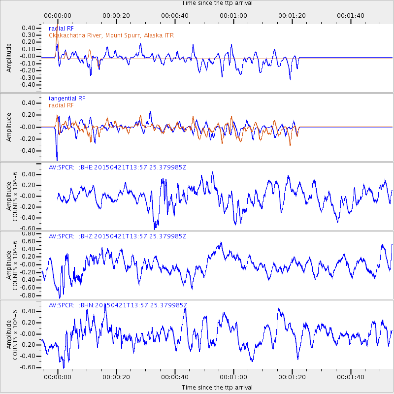
SPCR Ckakachatna River, Mount Spurr, Alaska - Earthquake Result Viewer
*The percent match for this event was below the threshold and hence no stack was calculated.
| Earthquake location: |
Fiji Islands Region |
| Earthquake latitude/longitude: |
-18.2/-178.1 |
| Earthquake time(UTC): |
2015/04/21 (111) 13:46:30 GMT |
| Earthquake Depth: |
494 km |
| Earthquake Magnitude: |
5.8 MW, 5.1 mb |
| Earthquake Catalog/Contributor: |
ISC/ISC |
|
| Network: |
AV Alaska Volcano Observatory |
| Station: |
SPCR Ckakachatna River, Mount Spurr, Alaska |
| Lat/Lon: |
61.20 N/152.21 W |
| Elevation: |
984 m |
|
| Distance: |
81.8 deg |
| Az: |
12.321 deg |
| Baz: |
204.767 deg |
| Ray Param: |
$rayparam |
*The percent match for this event was below the threshold and hence was not used in the summary stack. |
|
| Radial Match: |
67.84704 % |
| Radial Bump: |
400 |
| Transverse Match: |
51.90312 % |
| Transverse Bump: |
400 |
| SOD ConfigId: |
7422571 |
| Insert Time: |
2019-04-18 07:18:50.466 +0000 |
| GWidth: |
2.5 |
| Max Bumps: |
400 |
| Tol: |
0.001 |
|
Signal To Noise
| Channel | StoN | STA | LTA |
| AV:SPCR: :BHZ:20150421T13:57:25.379985Z | 1.4851295 | 5.2048046E-7 | 3.5046133E-7 |
| AV:SPCR: :BHN:20150421T13:57:25.379985Z | 1.2137076 | 3.6899894E-7 | 3.0402623E-7 |
| AV:SPCR: :BHE:20150421T13:57:25.379985Z | 3.2930746 | 3.315848E-7 | 1.0069156E-7 |
| Arrivals |
| Ps | |
| PpPs | |
| PsPs/PpSs | |


