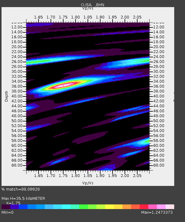
ISA Isabella - Earthquake Result Viewer

Earthquake location: Tonga Islands
Earthquake latitude/longitude: -15.1/-173.7
Earthquake time(UTC): 2003/05/03 (123) 05:03:03 GMT
Earthquake Depth: 33 km
Earthquake Magnitude: 6.3 MB, 6.1 MS, 6.2 MW, 6.1 MW
Earthquake Catalog/Contributor: WHDF/NEIC
Network: CI Caltech Regional Seismic Network
Station: ISA Isabella
Lat/Lon: 35.66 N/118.47 W
Elevation: 873 m
Distance: 72.7 deg
Az: 44.504 deg
Baz: 236.231 deg
Ray Param: 0.0534376
Estimated Moho Depth: 35.5 km
Estimated Crust Vp/Vs: 1.75
Assumed Crust Vp: 6.1 km/s
Estimated Crust Vs: 3.486 km/s
Estimated Crust Poisson's Ratio: 0.26
Radial Match: 88.09928 %
Radial Bump: 400
Transverse Match: 79.79082 %
Transverse Bump: 400
SOD ConfigId: 3787
Insert Time: 2010-02-25 21:14:46.709 +0000
GWidth: 2.5
Max Bumps: 400
Tol: 0.001

Signal To Noise

ChannelStoNSTALTA
CI:ISA: :BHN:20030503T05:13:57.030002Z1.55600881.656568E-71.06462636E-7
CI:ISA: :BHE:20030503T05:13:57.030002Z3.23537734.27805E-71.3222724E-7
CI:ISA: :BHZ:20030503T05:13:57.030002Z11.6361381.2382118E-61.06410894E-7
Arrivals
Ps4.5 SECOND
PpPs16 SECOND
PsPs/PpSs20 SECOND