You are here: Home > Network List > II - Global Seismograph Network (GSN - IRIS/IDA) Stations List
> Station ALE Alert, N.W.T., Canada > Earthquake Result Viewer
ALE Alert, N.W.T., Canada - Earthquake Result Viewer
| Earthquake location: |
Kuril Islands |
| Earthquake latitude/longitude: |
48.7/154.9 |
| Earthquake time(UTC): |
1991/07/13 (194) 12:15:13 GMT |
| Earthquake Depth: |
40 km |
| Earthquake Magnitude: |
5.7 MB, 5.9 MS, 5.7 UNKNOWN |
| Earthquake Catalog/Contributor: |
WHDF/NEIC |
|
| Network: |
II Global Seismograph Network (GSN - IRIS/IDA) |
| Station: |
ALE Alert, N.W.T., Canada |
| Lat/Lon: |
82.50 N/62.35 W |
| Elevation: |
60 m |
|
| Distance: |
47.6 deg |
| Az: |
6.182 deg |
| Baz: |
327.119 deg |
| Ray Param: |
0.06977059 |
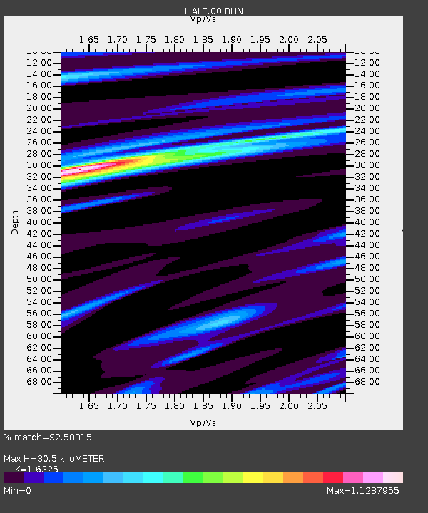
| Estimated Moho Depth: |
30.5 km |
| Estimated Crust Vp/Vs: |
1.63 |
| Assumed Crust Vp: |
6.287 km/s |
| Estimated Crust Vs: |
3.851 km/s |
| Estimated Crust Poisson's Ratio: |
0.20 |
|
| Radial Match: |
92.58315 % |
| Radial Bump: |
312 |
| Transverse Match: |
74.48143 % |
| Transverse Bump: |
400 |
| SOD ConfigId: |
61242 |
| Insert Time: |
2010-03-02 01:06:31.629 +0000 |
| GWidth: |
2.5 |
| Max Bumps: |
400 |
| Tol: |
0.001 |
|

Signal To Noise
| Channel | StoN | STA | LTA |
| II:ALE:00:BHN:19910713T12:23:14.942004Z | 17.928957 | 2.9189575E-6 | 1.6280688E-7 |
| II:ALE:00:BHE:19910713T12:23:14.943011Z | 8.045422 | 1.8865437E-6 | 2.3448663E-7 |
| II:ALE:00:BHZ:19910713T12:23:14.942004Z | 13.752012 | 6.88334E-6 | 5.005333E-7 |
| Arrivals |
| Ps | 3.3 SECOND |
| PpPs | 12 SECOND |
| PsPs/PpSs | 15 SECOND |


