You are here: Home > Network List > TA - USArray Transportable Network (new EarthScope stations) Stations List
> Station WHTX Lake Whitney, Meridian, TX, USA > Earthquake Result Viewer
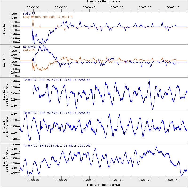
WHTX Lake Whitney, Meridian, TX, USA - Earthquake Result Viewer
*The percent match for this event was below the threshold and hence no stack was calculated.
| Earthquake location: |
Fiji Islands Region |
| Earthquake latitude/longitude: |
-18.2/-178.1 |
| Earthquake time(UTC): |
2015/04/21 (111) 13:46:30 GMT |
| Earthquake Depth: |
494 km |
| Earthquake Magnitude: |
5.8 MW, 5.1 mb |
| Earthquake Catalog/Contributor: |
ISC/ISC |
|
| Network: |
TA USArray Transportable Network (new EarthScope stations) |
| Station: |
WHTX Lake Whitney, Meridian, TX, USA |
| Lat/Lon: |
31.99 N/97.46 W |
| Elevation: |
190 m |
|
| Distance: |
91.8 deg |
| Az: |
57.009 deg |
| Baz: |
249.791 deg |
| Ray Param: |
$rayparam |
*The percent match for this event was below the threshold and hence was not used in the summary stack. |
|
| Radial Match: |
40.902153 % |
| Radial Bump: |
400 |
| Transverse Match: |
20.829943 % |
| Transverse Bump: |
400 |
| SOD ConfigId: |
7422571 |
| Insert Time: |
2019-04-18 07:21:42.082 +0000 |
| GWidth: |
2.5 |
| Max Bumps: |
400 |
| Tol: |
0.001 |
|
Signal To Noise
| Channel | StoN | STA | LTA |
| TA:WHTX: :BHZ:20150421T13:58:13.199016Z | 1.4768071 | 2.2371837E-7 | 1.5148787E-7 |
| TA:WHTX: :BHN:20150421T13:58:13.199016Z | 1.707419 | 8.551844E-7 | 5.008638E-7 |
| TA:WHTX: :BHE:20150421T13:58:13.199016Z | 1.3435401 | 2.3631617E-7 | 1.7589066E-7 |
| Arrivals |
| Ps | |
| PpPs | |
| PsPs/PpSs | |


