You are here: Home > Network List > PE - Penn State Network Stations List
> Station PAGS PA Geological Survey > Earthquake Result Viewer
PAGS PA Geological Survey - Earthquake Result Viewer
| Earthquake location: |
Central Peru |
| Earthquake latitude/longitude: |
-14.6/-73.6 |
| Earthquake time(UTC): |
2014/08/24 (236) 23:21:45 GMT |
| Earthquake Depth: |
101 km |
| Earthquake Magnitude: |
6.9 MWW, 6.8 MI, 6.9 MWB |
| Earthquake Catalog/Contributor: |
NEIC PDE/NEIC COMCAT |
|
| Network: |
PE Penn State Network |
| Station: |
PAGS PA Geological Survey |
| Lat/Lon: |
40.23 N/76.72 W |
| Elevation: |
120 m |
|
| Distance: |
54.6 deg |
| Az: |
357.047 deg |
| Baz: |
176.265 deg |
| Ray Param: |
0.06502822 |
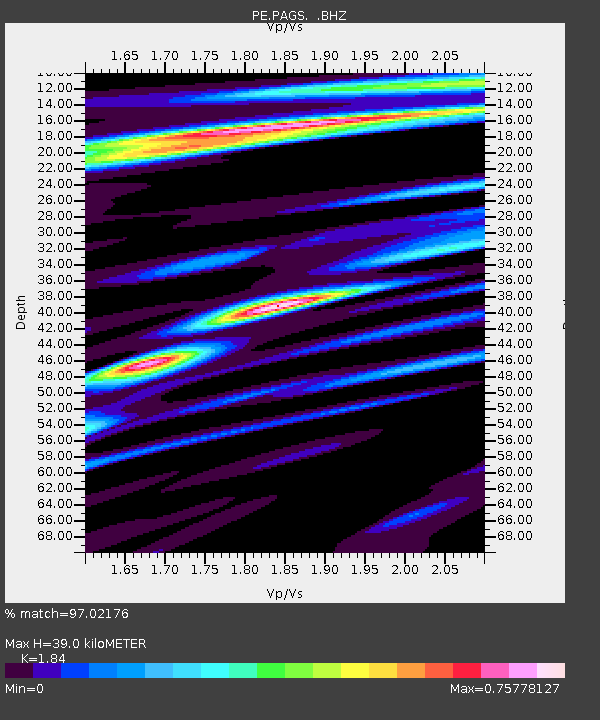
| Estimated Moho Depth: |
39.0 km |
| Estimated Crust Vp/Vs: |
1.84 |
| Assumed Crust Vp: |
6.121 km/s |
| Estimated Crust Vs: |
3.326 km/s |
| Estimated Crust Poisson's Ratio: |
0.29 |
|
| Radial Match: |
97.02176 % |
| Radial Bump: |
395 |
| Transverse Match: |
89.381874 % |
| Transverse Bump: |
400 |
| SOD ConfigId: |
769524 |
| Insert Time: |
2014-09-07 23:55:20.998 +0000 |
| GWidth: |
2.5 |
| Max Bumps: |
400 |
| Tol: |
0.001 |
|
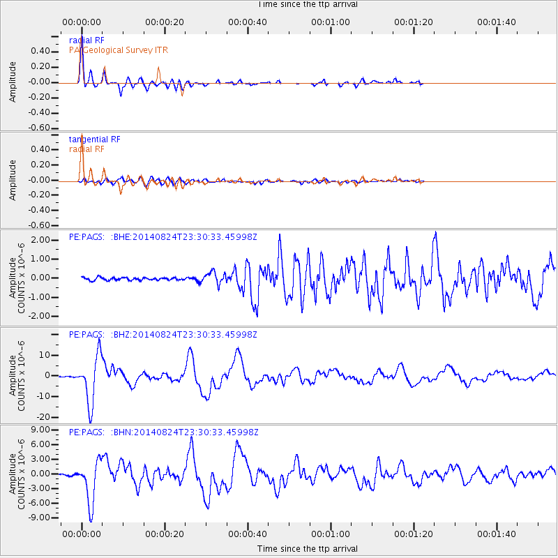
Signal To Noise
| Channel | StoN | STA | LTA |
| PE:PAGS: :BHZ:20140824T23:30:33.45998Z | 88.73801 | 1.1704115E-5 | 1.3189519E-7 |
| PE:PAGS: :BHN:20140824T23:30:33.45998Z | 29.42426 | 4.462959E-6 | 1.5167618E-7 |
| PE:PAGS: :BHE:20140824T23:30:33.45998Z | 4.5334373 | 3.0252122E-7 | 6.673109E-8 |
| Arrivals |
| Ps | 5.6 SECOND |
| PpPs | 17 SECOND |
| PsPs/PpSs | 23 SECOND |


