You are here: Home > Network List > II - Global Seismograph Network (GSN - IRIS/IDA) Stations List
> Station ALE Alert, N.W.T., Canada > Earthquake Result Viewer
ALE Alert, N.W.T., Canada - Earthquake Result Viewer
| Earthquake location: |
Near Coast Of Northern Calif. |
| Earthquake latitude/longitude: |
40.4/-124.6 |
| Earthquake time(UTC): |
1992/04/26 (117) 11:18:25 GMT |
| Earthquake Depth: |
22 km |
| Earthquake Magnitude: |
6.6 MB, 6.7 MS |
| Earthquake Catalog/Contributor: |
WHDF/NEIC |
|
| Network: |
II Global Seismograph Network (GSN - IRIS/IDA) |
| Station: |
ALE Alert, N.W.T., Canada |
| Lat/Lon: |
82.50 N/62.35 W |
| Elevation: |
60 m |
|
| Distance: |
46.6 deg |
| Az: |
9.195 deg |
| Baz: |
248.36 deg |
| Ray Param: |
0.07048216 |
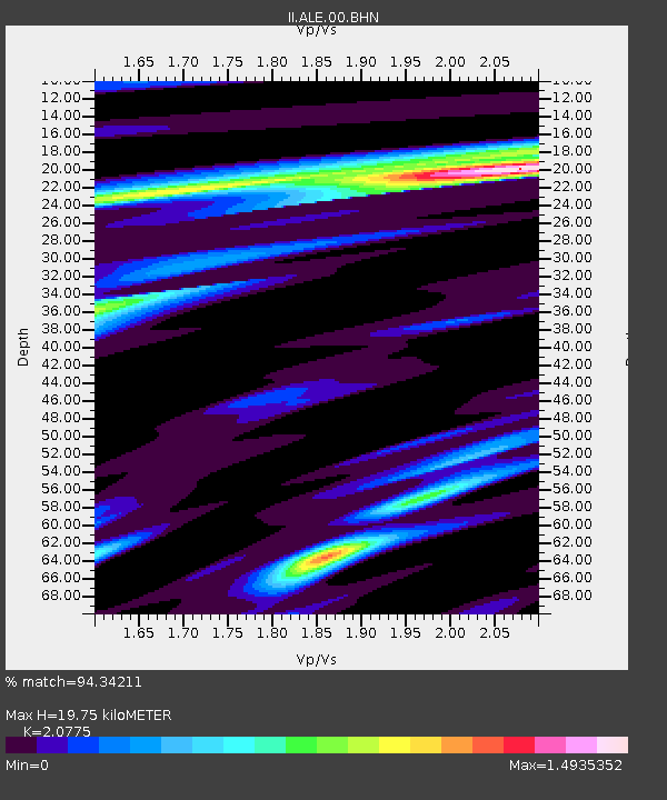
| Estimated Moho Depth: |
19.75 km |
| Estimated Crust Vp/Vs: |
2.08 |
| Assumed Crust Vp: |
6.287 km/s |
| Estimated Crust Vs: |
3.026 km/s |
| Estimated Crust Poisson's Ratio: |
0.35 |
|
| Radial Match: |
94.34211 % |
| Radial Bump: |
333 |
| Transverse Match: |
77.45579 % |
| Transverse Bump: |
400 |
| SOD ConfigId: |
61242 |
| Insert Time: |
2010-03-02 01:07:18.404 +0000 |
| GWidth: |
2.5 |
| Max Bumps: |
400 |
| Tol: |
0.001 |
|

Signal To Noise
| Channel | StoN | STA | LTA |
| II:ALE:00:BHN:19920426T11:26:21.607013Z | 2.1437569 | 8.339103E-7 | 3.889948E-7 |
| II:ALE:00:BHE:19920426T11:26:21.607013Z | 5.6604548 | 1.8922174E-6 | 3.3428717E-7 |
| II:ALE:00:BHZ:19920426T11:26:21.607013Z | 6.020527 | 3.1505986E-6 | 5.2330944E-7 |
| Arrivals |
| Ps | 3.6 SECOND |
| PpPs | 9.2 SECOND |
| PsPs/PpSs | 13 SECOND |


