You are here: Home > Network List > TA - USArray Transportable Network (new EarthScope stations) Stations List
> Station F04D Rainier, OR, USA > Earthquake Result Viewer
F04D Rainier, OR, USA - Earthquake Result Viewer
| Earthquake location: |
Central Peru |
| Earthquake latitude/longitude: |
-14.6/-73.6 |
| Earthquake time(UTC): |
2014/08/24 (236) 23:21:45 GMT |
| Earthquake Depth: |
101 km |
| Earthquake Magnitude: |
6.9 MWW, 6.8 MI, 6.9 MWB |
| Earthquake Catalog/Contributor: |
NEIC PDE/NEIC COMCAT |
|
| Network: |
TA USArray Transportable Network (new EarthScope stations) |
| Station: |
F04D Rainier, OR, USA |
| Lat/Lon: |
46.08 N/123.01 W |
| Elevation: |
236 m |
|
| Distance: |
75.0 deg |
| Az: |
326.815 deg |
| Baz: |
130.415 deg |
| Ray Param: |
0.051714838 |
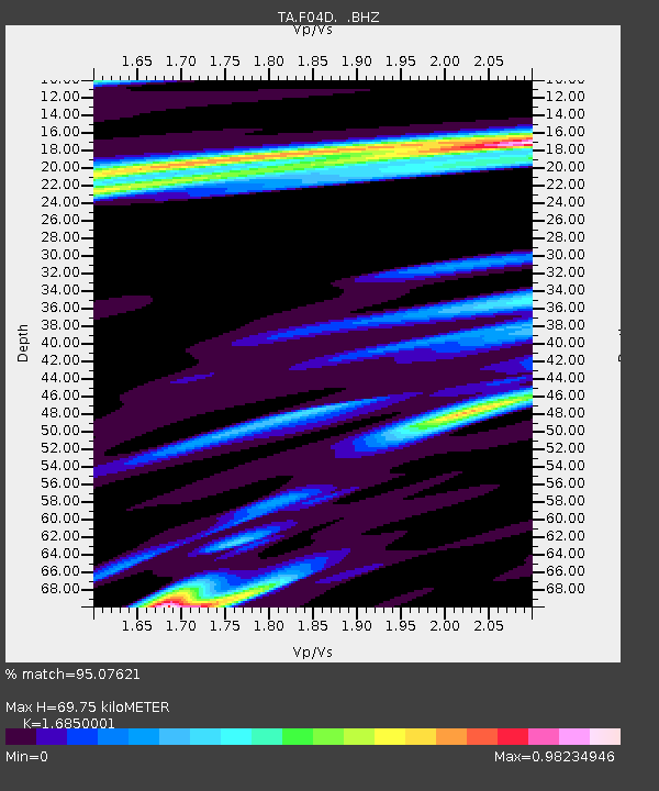
| Estimated Moho Depth: |
69.75 km |
| Estimated Crust Vp/Vs: |
1.69 |
| Assumed Crust Vp: |
6.566 km/s |
| Estimated Crust Vs: |
3.897 km/s |
| Estimated Crust Poisson's Ratio: |
0.23 |
|
| Radial Match: |
95.07621 % |
| Radial Bump: |
400 |
| Transverse Match: |
90.58549 % |
| Transverse Bump: |
400 |
| SOD ConfigId: |
769524 |
| Insert Time: |
2014-09-08 00:00:28.057 +0000 |
| GWidth: |
2.5 |
| Max Bumps: |
400 |
| Tol: |
0.001 |
|

Signal To Noise
| Channel | StoN | STA | LTA |
| TA:F04D: :BHZ:20140824T23:32:45.524006Z | 47.93354 | 1.1266157E-5 | 2.3503705E-7 |
| TA:F04D: :BHN:20140824T23:32:45.524006Z | 7.402613 | 2.894831E-6 | 3.9105527E-7 |
| TA:F04D: :BHE:20140824T23:32:45.524006Z | 10.38659 | 3.6400168E-6 | 3.504535E-7 |
| Arrivals |
| Ps | 7.5 SECOND |
| PpPs | 28 SECOND |
| PsPs/PpSs | 35 SECOND |


