You are here: Home > Network List > TA - USArray Transportable Network (new EarthScope stations) Stations List
> Station F62A Pittston Farm, Pittston Academy Grant, ME, USA > Earthquake Result Viewer
F62A Pittston Farm, Pittston Academy Grant, ME, USA - Earthquake Result Viewer
| Earthquake location: |
Central Peru |
| Earthquake latitude/longitude: |
-14.6/-73.6 |
| Earthquake time(UTC): |
2014/08/24 (236) 23:21:45 GMT |
| Earthquake Depth: |
101 km |
| Earthquake Magnitude: |
6.9 MWW, 6.8 MI, 6.9 MWB |
| Earthquake Catalog/Contributor: |
NEIC PDE/NEIC COMCAT |
|
| Network: |
TA USArray Transportable Network (new EarthScope stations) |
| Station: |
F62A Pittston Farm, Pittston Academy Grant, ME, USA |
| Lat/Lon: |
45.90 N/69.97 W |
| Elevation: |
331 m |
|
| Distance: |
60.3 deg |
| Az: |
2.903 deg |
| Baz: |
184.026 deg |
| Ray Param: |
0.061342806 |
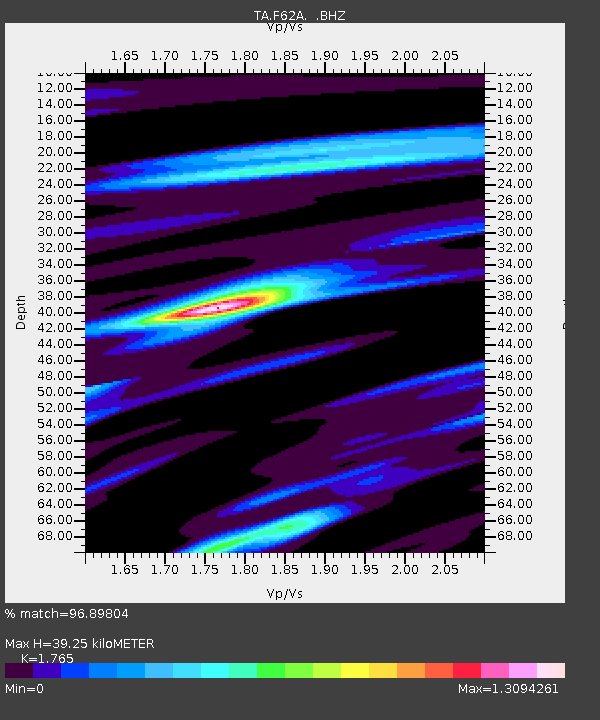
| Estimated Moho Depth: |
39.25 km |
| Estimated Crust Vp/Vs: |
1.76 |
| Assumed Crust Vp: |
6.419 km/s |
| Estimated Crust Vs: |
3.637 km/s |
| Estimated Crust Poisson's Ratio: |
0.26 |
|
| Radial Match: |
96.89804 % |
| Radial Bump: |
309 |
| Transverse Match: |
91.32193 % |
| Transverse Bump: |
400 |
| SOD ConfigId: |
769524 |
| Insert Time: |
2014-09-08 00:00:51.237 +0000 |
| GWidth: |
2.5 |
| Max Bumps: |
400 |
| Tol: |
0.001 |
|

Signal To Noise
| Channel | StoN | STA | LTA |
| TA:F62A: :BHZ:20140824T23:31:13.224019Z | 41.52118 | 7.805374E-6 | 1.8798535E-7 |
| TA:F62A: :BHN:20140824T23:31:13.224019Z | 47.680878 | 4.7361955E-6 | 9.933113E-8 |
| TA:F62A: :BHE:20140824T23:31:13.224019Z | 3.8028553 | 4.0905078E-7 | 1.0756412E-7 |
| Arrivals |
| Ps | 4.9 SECOND |
| PpPs | 16 SECOND |
| PsPs/PpSs | 21 SECOND |


