You are here: Home > Network List > TA - USArray Transportable Network (new EarthScope stations) Stations List
> Station H66A Whiting, ME, USA > Earthquake Result Viewer
H66A Whiting, ME, USA - Earthquake Result Viewer
| Earthquake location: |
Central Peru |
| Earthquake latitude/longitude: |
-14.6/-73.6 |
| Earthquake time(UTC): |
2014/08/24 (236) 23:21:45 GMT |
| Earthquake Depth: |
101 km |
| Earthquake Magnitude: |
6.9 MWW, 6.8 MI, 6.9 MWB |
| Earthquake Catalog/Contributor: |
NEIC PDE/NEIC COMCAT |
|
| Network: |
TA USArray Transportable Network (new EarthScope stations) |
| Station: |
H66A Whiting, ME, USA |
| Lat/Lon: |
44.79 N/67.31 W |
| Elevation: |
55 m |
|
| Distance: |
59.4 deg |
| Az: |
5.183 deg |
| Baz: |
187.055 deg |
| Ray Param: |
0.061947003 |
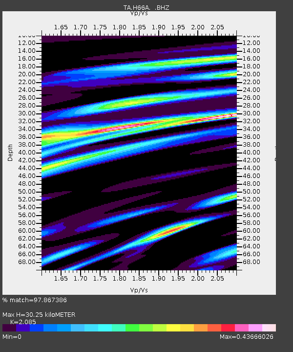
| Estimated Moho Depth: |
30.25 km |
| Estimated Crust Vp/Vs: |
2.09 |
| Assumed Crust Vp: |
6.419 km/s |
| Estimated Crust Vs: |
3.079 km/s |
| Estimated Crust Poisson's Ratio: |
0.35 |
|
| Radial Match: |
97.867386 % |
| Radial Bump: |
299 |
| Transverse Match: |
86.1505 % |
| Transverse Bump: |
400 |
| SOD ConfigId: |
769524 |
| Insert Time: |
2014-09-08 00:02:01.727 +0000 |
| GWidth: |
2.5 |
| Max Bumps: |
400 |
| Tol: |
0.001 |
|

Signal To Noise
| Channel | StoN | STA | LTA |
| TA:H66A: :BHZ:20140824T23:31:06.899983Z | 44.597626 | 9.41786E-6 | 2.1117404E-7 |
| TA:H66A: :BHN:20140824T23:31:06.899983Z | 44.489914 | 4.7208464E-6 | 1.0611049E-7 |
| TA:H66A: :BHE:20140824T23:31:06.899983Z | 7.384007 | 7.8332937E-7 | 1.0608459E-7 |
| Arrivals |
| Ps | 5.3 SECOND |
| PpPs | 14 SECOND |
| PsPs/PpSs | 19 SECOND |


