You are here: Home > Network List > TA - USArray Transportable Network (new EarthScope stations) Stations List
> Station I59A Olmsteadville, NY, USA > Earthquake Result Viewer
I59A Olmsteadville, NY, USA - Earthquake Result Viewer

| Earthquake location: |
Central Peru |
| Earthquake latitude/longitude: |
-14.6/-73.6 |
| Earthquake time(UTC): |
2014/08/24 (236) 23:21:45 GMT |
| Earthquake Depth: |
101 km |
| Earthquake Magnitude: |
6.9 MWW, 6.8 MI, 6.9 MWB |
| Earthquake Catalog/Contributor: |
NEIC PDE/NEIC COMCAT |
|
| Network: |
TA USArray Transportable Network (new EarthScope stations) |
| Station: |
I59A Olmsteadville, NY, USA |
| Lat/Lon: |
43.80 N/73.87 W |
| Elevation: |
390 m |
|
| Distance: |
58.1 deg |
| Az: |
359.747 deg |
| Baz: |
179.662 deg |
| Ray Param: |
0.0627719 |
| Estimated Moho Depth: |
41.75 km |
| Estimated Crust Vp/Vs: |
1.78 |
| Assumed Crust Vp: |
6.419 km/s |
| Estimated Crust Vs: |
3.601 km/s |
| Estimated Crust Poisson's Ratio: |
0.27 |
|
| Radial Match: |
98.260605 % |
| Radial Bump: |
244 |
| Transverse Match: |
90.68634 % |
| Transverse Bump: |
400 |
| SOD ConfigId: |
769524 |
| Insert Time: |
2014-09-08 00:02:25.663 +0000 |
| GWidth: |
2.5 |
| Max Bumps: |
400 |
| Tol: |
0.001 |
|
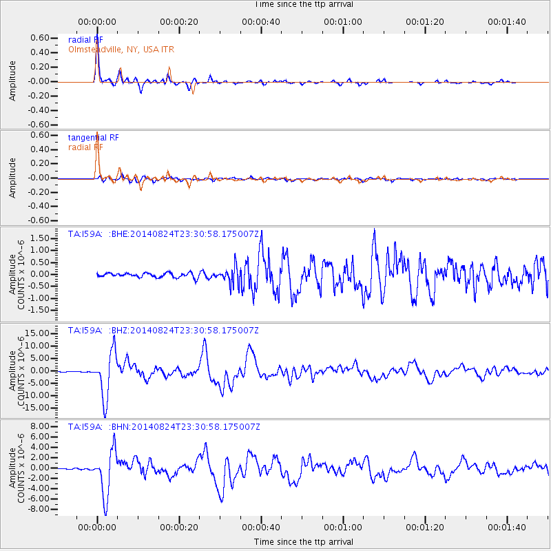
Signal To Noise
| Channel | StoN | STA | LTA |
| TA:I59A: :BHZ:20140824T23:30:58.175007Z | 109.14189 | 9.509361E-6 | 8.712842E-8 |
| TA:I59A: :BHN:20140824T23:30:58.175007Z | 75.47748 | 4.5148217E-6 | 5.9816806E-8 |
| TA:I59A: :BHE:20140824T23:30:58.175007Z | 3.8454497 | 3.5300997E-7 | 9.179939E-8 |
| Arrivals |
| Ps | 5.3 SECOND |
| PpPs | 17 SECOND |
| PsPs/PpSs | 23 SECOND |


