You are here: Home > Network List > TA - USArray Transportable Network (new EarthScope stations) Stations List
> Station I64A Boothbay, ME, USA > Earthquake Result Viewer
I64A Boothbay, ME, USA - Earthquake Result Viewer
| Earthquake location: |
Central Peru |
| Earthquake latitude/longitude: |
-14.6/-73.6 |
| Earthquake time(UTC): |
2014/08/24 (236) 23:21:45 GMT |
| Earthquake Depth: |
101 km |
| Earthquake Magnitude: |
6.9 MWW, 6.8 MI, 6.9 MWB |
| Earthquake Catalog/Contributor: |
NEIC PDE/NEIC COMCAT |
|
| Network: |
TA USArray Transportable Network (new EarthScope stations) |
| Station: |
I64A Boothbay, ME, USA |
| Lat/Lon: |
43.92 N/69.63 W |
| Elevation: |
17 m |
|
| Distance: |
58.3 deg |
| Az: |
3.347 deg |
| Baz: |
184.486 deg |
| Ray Param: |
0.06261972 |
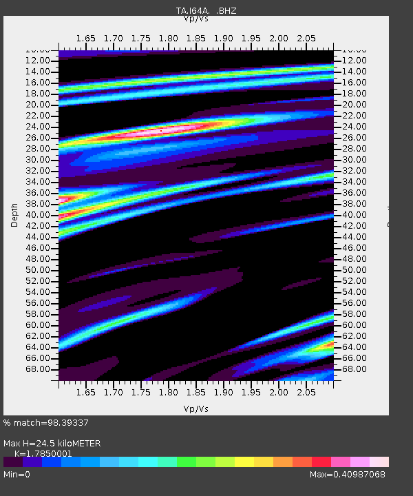
| Estimated Moho Depth: |
24.5 km |
| Estimated Crust Vp/Vs: |
1.79 |
| Assumed Crust Vp: |
6.419 km/s |
| Estimated Crust Vs: |
3.596 km/s |
| Estimated Crust Poisson's Ratio: |
0.27 |
|
| Radial Match: |
98.39337 % |
| Radial Bump: |
258 |
| Transverse Match: |
89.26388 % |
| Transverse Bump: |
400 |
| SOD ConfigId: |
769524 |
| Insert Time: |
2014-09-08 00:02:35.073 +0000 |
| GWidth: |
2.5 |
| Max Bumps: |
400 |
| Tol: |
0.001 |
|

Signal To Noise
| Channel | StoN | STA | LTA |
| TA:I64A: :BHZ:20140824T23:30:59.79897Z | 54.927086 | 8.924477E-6 | 1.6247861E-7 |
| TA:I64A: :BHN:20140824T23:30:59.79897Z | 32.205433 | 4.745461E-6 | 1.4734971E-7 |
| TA:I64A: :BHE:20140824T23:30:59.79897Z | 5.078239 | 6.430631E-7 | 1.2663112E-7 |
| Arrivals |
| Ps | 3.1 SECOND |
| PpPs | 10 SECOND |
| PsPs/PpSs | 13 SECOND |


