You are here: Home > Network List > II - Global Seismograph Network (GSN - IRIS/IDA) Stations List
> Station WRAB Tennant Creek, NT, Australia > Earthquake Result Viewer
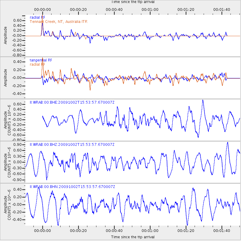
WRAB Tennant Creek, NT, Australia - Earthquake Result Viewer
*The percent match for this event was below the threshold and hence no stack was calculated.
| Earthquake location: |
Fiji Islands Region |
| Earthquake latitude/longitude: |
-17.0/174.5 |
| Earthquake time(UTC): |
2009/10/02 (275) 15:47:09 GMT |
| Earthquake Depth: |
10 km |
| Earthquake Magnitude: |
5.7 MB, 5.6 MS, 6.0 MW, 5.8 MW |
| Earthquake Catalog/Contributor: |
WHDF/NEIC |
|
| Network: |
II Global Seismograph Network (GSN - IRIS/IDA) |
| Station: |
WRAB Tennant Creek, NT, Australia |
| Lat/Lon: |
19.93 S/134.36 E |
| Elevation: |
366 m |
|
| Distance: |
38.1 deg |
| Az: |
259.258 deg |
| Baz: |
92.393 deg |
| Ray Param: |
$rayparam |
*The percent match for this event was below the threshold and hence was not used in the summary stack. |
|
| Radial Match: |
67.45703 % |
| Radial Bump: |
400 |
| Transverse Match: |
56.163006 % |
| Transverse Bump: |
400 |
| SOD ConfigId: |
1 |
| Insert Time: |
2010-02-19 00:28:09.631 +0000 |
| GWidth: |
2.5 |
| Max Bumps: |
400 |
| Tol: |
0.001 |
|
Signal To Noise
| Channel | StoN | STA | LTA |
| II:WRAB:00:BHZ:20091002T15:53:57.670007Z | 2.2792478 | 4.2070462E-7 | 1.8458047E-7 |
| II:WRAB:00:BHN:20091002T15:53:57.670007Z | 1.7659725 | 2.8444953E-7 | 1.6107246E-7 |
| II:WRAB:00:BHE:20091002T15:53:57.670007Z | 0.6646687 | 1.2316306E-7 | 1.8529994E-7 |
| Arrivals |
| Ps | |
| PpPs | |
| PsPs/PpSs | |


