You are here: Home > Network List > TA - USArray Transportable Network (new EarthScope stations) Stations List
> Station L57A Andrews Acres Farm, Gillet, PA, USA > Earthquake Result Viewer
L57A Andrews Acres Farm, Gillet, PA, USA - Earthquake Result Viewer
| Earthquake location: |
Central Peru |
| Earthquake latitude/longitude: |
-14.6/-73.6 |
| Earthquake time(UTC): |
2014/08/24 (236) 23:21:45 GMT |
| Earthquake Depth: |
101 km |
| Earthquake Magnitude: |
6.9 MWW, 6.8 MI, 6.9 MWB |
| Earthquake Catalog/Contributor: |
NEIC PDE/NEIC COMCAT |
|
| Network: |
TA USArray Transportable Network (new EarthScope stations) |
| Station: |
L57A Andrews Acres Farm, Gillet, PA, USA |
| Lat/Lon: |
42.00 N/76.85 W |
| Elevation: |
546 m |
|
| Distance: |
56.4 deg |
| Az: |
357.072 deg |
| Baz: |
176.196 deg |
| Ray Param: |
0.06387469 |
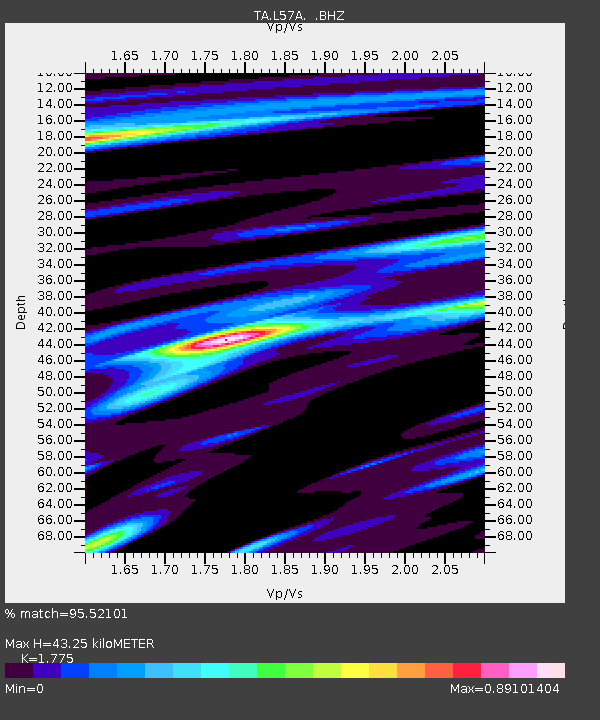
| Estimated Moho Depth: |
43.25 km |
| Estimated Crust Vp/Vs: |
1.77 |
| Assumed Crust Vp: |
6.476 km/s |
| Estimated Crust Vs: |
3.648 km/s |
| Estimated Crust Poisson's Ratio: |
0.27 |
|
| Radial Match: |
95.52101 % |
| Radial Bump: |
364 |
| Transverse Match: |
89.90851 % |
| Transverse Bump: |
400 |
| SOD ConfigId: |
769524 |
| Insert Time: |
2014-09-08 00:04:02.588 +0000 |
| GWidth: |
2.5 |
| Max Bumps: |
400 |
| Tol: |
0.001 |
|
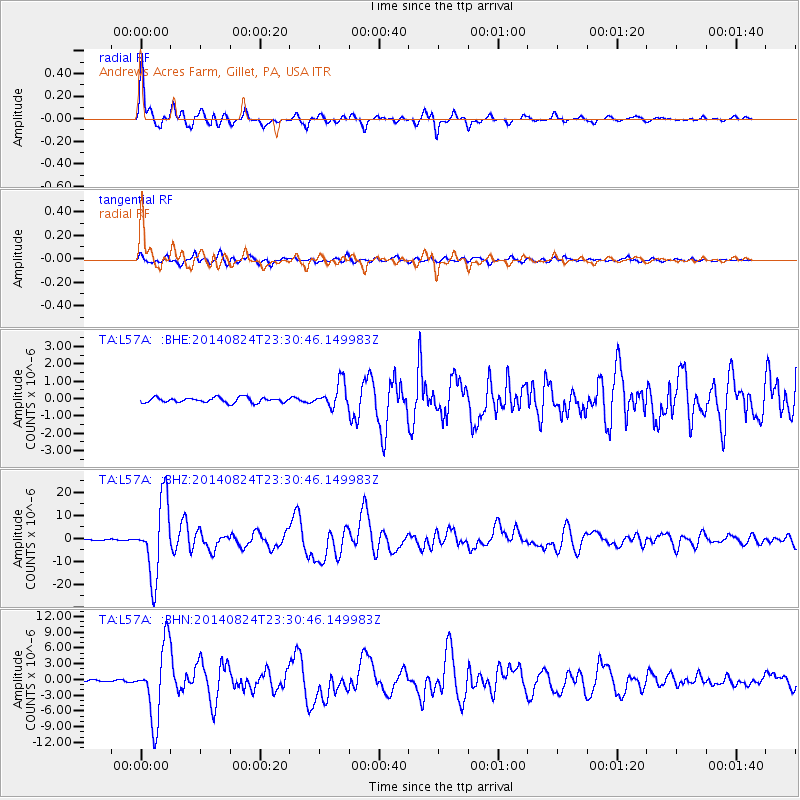
Signal To Noise
| Channel | StoN | STA | LTA |
| TA:L57A: :BHZ:20140824T23:30:46.149983Z | 91.88986 | 1.6359894E-5 | 1.7803806E-7 |
| TA:L57A: :BHN:20140824T23:30:46.149983Z | 55.089806 | 6.999778E-6 | 1.2706123E-7 |
| TA:L57A: :BHE:20140824T23:30:46.149983Z | 4.8388886 | 7.147135E-7 | 1.47702E-7 |
| Arrivals |
| Ps | 5.4 SECOND |
| PpPs | 18 SECOND |
| PsPs/PpSs | 23 SECOND |


