You are here: Home > Network List > TA - USArray Transportable Network (new EarthScope stations) Stations List
> Station O03E Paynes Creek, CA, USA > Earthquake Result Viewer
O03E Paynes Creek, CA, USA - Earthquake Result Viewer
| Earthquake location: |
Central Peru |
| Earthquake latitude/longitude: |
-14.6/-73.6 |
| Earthquake time(UTC): |
2014/08/24 (236) 23:21:45 GMT |
| Earthquake Depth: |
101 km |
| Earthquake Magnitude: |
6.9 MWW, 6.8 MI, 6.9 MWB |
| Earthquake Catalog/Contributor: |
NEIC PDE/NEIC COMCAT |
|
| Network: |
TA USArray Transportable Network (new EarthScope stations) |
| Station: |
O03E Paynes Creek, CA, USA |
| Lat/Lon: |
40.29 N/121.80 W |
| Elevation: |
967 m |
|
| Distance: |
70.6 deg |
| Az: |
322.79 deg |
| Baz: |
130.05 deg |
| Ray Param: |
0.05462305 |
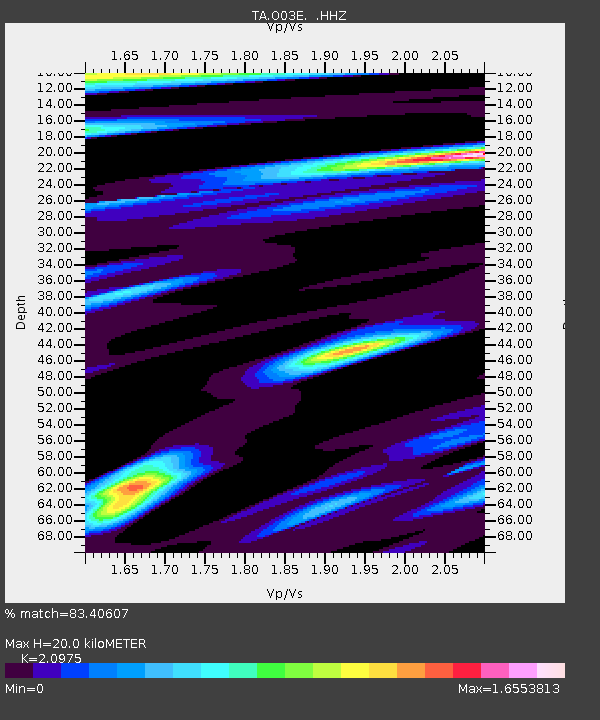
| Estimated Moho Depth: |
20.0 km |
| Estimated Crust Vp/Vs: |
2.10 |
| Assumed Crust Vp: |
6.566 km/s |
| Estimated Crust Vs: |
3.13 km/s |
| Estimated Crust Poisson's Ratio: |
0.35 |
|
| Radial Match: |
83.40607 % |
| Radial Bump: |
400 |
| Transverse Match: |
76.179115 % |
| Transverse Bump: |
400 |
| SOD ConfigId: |
769524 |
| Insert Time: |
2014-09-08 00:05:44.460 +0000 |
| GWidth: |
2.5 |
| Max Bumps: |
400 |
| Tol: |
0.001 |
|
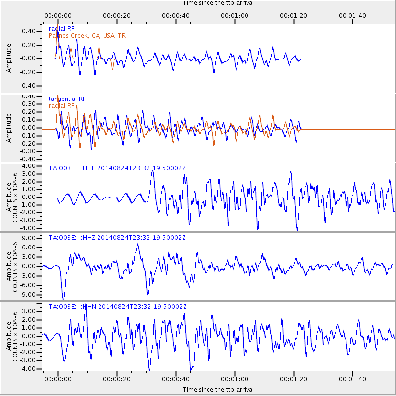
Signal To Noise
| Channel | StoN | STA | LTA |
| TA:O03E: :HHZ:20140824T23:32:19.50002Z | 16.066797 | 4.5836946E-6 | 2.8528987E-7 |
| TA:O03E: :HHN:20140824T23:32:19.50002Z | 3.677129 | 1.4640977E-6 | 3.9816328E-7 |
| TA:O03E: :HHE:20140824T23:32:19.50002Z | 4.394506 | 1.6793416E-6 | 3.821457E-7 |
| Arrivals |
| Ps | 3.5 SECOND |
| PpPs | 9.1 SECOND |
| PsPs/PpSs | 13 SECOND |


