You are here: Home > Network List > TA - USArray Transportable Network (new EarthScope stations) Stations List
> Station P51A Williamsport, OH, USA > Earthquake Result Viewer
P51A Williamsport, OH, USA - Earthquake Result Viewer
| Earthquake location: |
Central Peru |
| Earthquake latitude/longitude: |
-14.6/-73.6 |
| Earthquake time(UTC): |
2014/08/24 (236) 23:21:45 GMT |
| Earthquake Depth: |
101 km |
| Earthquake Magnitude: |
6.9 MWW, 6.8 MI, 6.9 MWB |
| Earthquake Catalog/Contributor: |
NEIC PDE/NEIC COMCAT |
|
| Network: |
TA USArray Transportable Network (new EarthScope stations) |
| Station: |
P51A Williamsport, OH, USA |
| Lat/Lon: |
39.48 N/83.06 W |
| Elevation: |
211 m |
|
| Distance: |
54.5 deg |
| Az: |
350.991 deg |
| Baz: |
168.703 deg |
| Ray Param: |
0.06509449 |
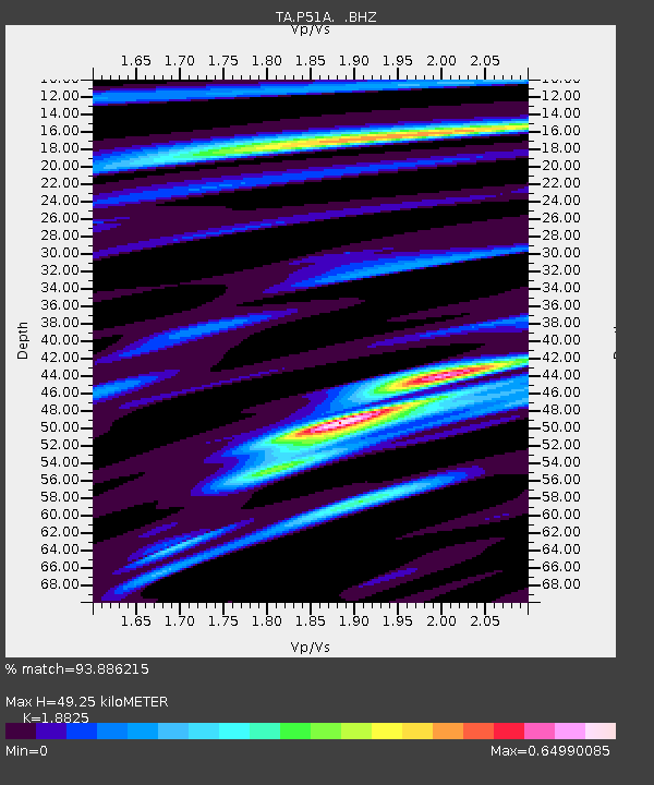
| Estimated Moho Depth: |
49.25 km |
| Estimated Crust Vp/Vs: |
1.88 |
| Assumed Crust Vp: |
6.232 km/s |
| Estimated Crust Vs: |
3.31 km/s |
| Estimated Crust Poisson's Ratio: |
0.30 |
|
| Radial Match: |
93.886215 % |
| Radial Bump: |
384 |
| Transverse Match: |
80.749214 % |
| Transverse Bump: |
400 |
| SOD ConfigId: |
769524 |
| Insert Time: |
2014-09-08 00:06:16.373 +0000 |
| GWidth: |
2.5 |
| Max Bumps: |
400 |
| Tol: |
0.001 |
|

Signal To Noise
| Channel | StoN | STA | LTA |
| TA:P51A: :BHZ:20140824T23:30:32.75002Z | 46.433857 | 6.3717453E-6 | 1.3722197E-7 |
| TA:P51A: :BHN:20140824T23:30:32.75002Z | 30.828651 | 3.149064E-6 | 1.0214731E-7 |
| TA:P51A: :BHE:20140824T23:30:32.75002Z | 7.5602465 | 9.806934E-7 | 1.2971711E-7 |
| Arrivals |
| Ps | 7.3 SECOND |
| PpPs | 22 SECOND |
| PsPs/PpSs | 29 SECOND |


