You are here: Home > Network List > TA - USArray Transportable Network (new EarthScope stations) Stations List
> Station P55A Reedsville, WV, USA > Earthquake Result Viewer
P55A Reedsville, WV, USA - Earthquake Result Viewer
| Earthquake location: |
Central Peru |
| Earthquake latitude/longitude: |
-14.6/-73.6 |
| Earthquake time(UTC): |
2014/08/24 (236) 23:21:45 GMT |
| Earthquake Depth: |
101 km |
| Earthquake Magnitude: |
6.9 MWW, 6.8 MI, 6.9 MWB |
| Earthquake Catalog/Contributor: |
NEIC PDE/NEIC COMCAT |
|
| Network: |
TA USArray Transportable Network (new EarthScope stations) |
| Station: |
P55A Reedsville, WV, USA |
| Lat/Lon: |
39.51 N/79.83 W |
| Elevation: |
551 m |
|
| Distance: |
54.1 deg |
| Az: |
354.035 deg |
| Baz: |
172.527 deg |
| Ray Param: |
0.06534409 |
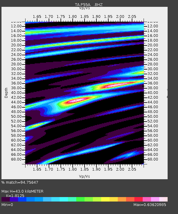
| Estimated Moho Depth: |
43.0 km |
| Estimated Crust Vp/Vs: |
1.81 |
| Assumed Crust Vp: |
6.159 km/s |
| Estimated Crust Vs: |
3.398 km/s |
| Estimated Crust Poisson's Ratio: |
0.28 |
|
| Radial Match: |
94.75647 % |
| Radial Bump: |
400 |
| Transverse Match: |
82.76301 % |
| Transverse Bump: |
400 |
| SOD ConfigId: |
769524 |
| Insert Time: |
2014-09-08 00:06:25.354 +0000 |
| GWidth: |
2.5 |
| Max Bumps: |
400 |
| Tol: |
0.001 |
|

Signal To Noise
| Channel | StoN | STA | LTA |
| TA:P55A: :BHZ:20140824T23:30:29.974995Z | 39.893444 | 9.9521785E-6 | 2.4946902E-7 |
| TA:P55A: :BHN:20140824T23:30:29.974995Z | 28.68237 | 3.5918001E-6 | 1.2522676E-7 |
| TA:P55A: :BHE:20140824T23:30:29.974995Z | 1.9421108 | 2.8900368E-7 | 1.4880905E-7 |
| Arrivals |
| Ps | 5.9 SECOND |
| PpPs | 19 SECOND |
| PsPs/PpSs | 25 SECOND |


