You are here: Home > Network List > TA - USArray Transportable Network (new EarthScope stations) Stations List
> Station P61A Hammonton, NJ, USA > Earthquake Result Viewer
P61A Hammonton, NJ, USA - Earthquake Result Viewer
| Earthquake location: |
Central Peru |
| Earthquake latitude/longitude: |
-14.6/-73.6 |
| Earthquake time(UTC): |
2014/08/24 (236) 23:21:45 GMT |
| Earthquake Depth: |
101 km |
| Earthquake Magnitude: |
6.9 MWW, 6.8 MI, 6.9 MWB |
| Earthquake Catalog/Contributor: |
NEIC PDE/NEIC COMCAT |
|
| Network: |
TA USArray Transportable Network (new EarthScope stations) |
| Station: |
P61A Hammonton, NJ, USA |
| Lat/Lon: |
39.67 N/74.79 W |
| Elevation: |
22 m |
|
| Distance: |
54.0 deg |
| Az: |
358.842 deg |
| Baz: |
178.547 deg |
| Ray Param: |
0.065429725 |
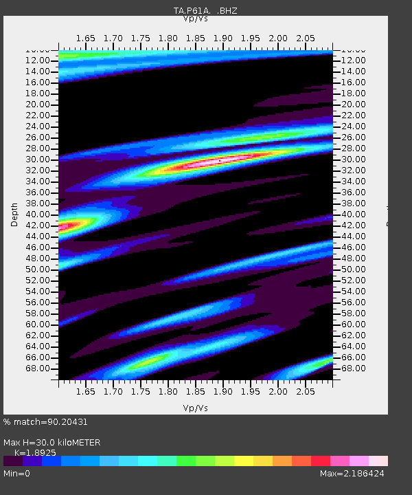
| Estimated Moho Depth: |
30.0 km |
| Estimated Crust Vp/Vs: |
1.89 |
| Assumed Crust Vp: |
6.287 km/s |
| Estimated Crust Vs: |
3.322 km/s |
| Estimated Crust Poisson's Ratio: |
0.31 |
|
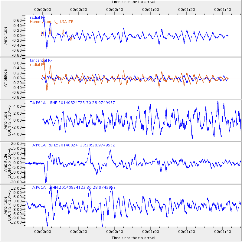
| Radial Match: |
90.20431 % |
| Radial Bump: |
400 |
| Transverse Match: |
81.2214 % |
| Transverse Bump: |
386 |
| SOD ConfigId: |
769524 |
| Insert Time: |
2014-09-08 00:06:38.221 +0000 |
| GWidth: |
2.5 |
| Max Bumps: |
400 |
| Tol: |
0.001 |
|
Signal To Noise
| Channel | StoN | STA | LTA |
| TA:P61A: :BHZ:20140824T23:30:28.974995Z | 19.910677 | 8.890651E-6 | 4.4652677E-7 |
| TA:P61A: :BHN:20140824T23:30:28.974995Z | 5.351252 | 7.610936E-6 | 1.4222719E-6 |
| TA:P61A: :BHE:20140824T23:30:28.974995Z | 1.2978289 | 1.4767955E-6 | 1.1378969E-6 |
| Arrivals |
| Ps | 4.5 SECOND |
| PpPs | 13 SECOND |
| PsPs/PpSs | 18 SECOND |


