You are here: Home > Network List > TA - USArray Transportable Network (new EarthScope stations) Stations List
> Station Q54A Coxs Mills, WV, USA > Earthquake Result Viewer
Q54A Coxs Mills, WV, USA - Earthquake Result Viewer

| Earthquake location: |
Central Peru |
| Earthquake latitude/longitude: |
-14.6/-73.6 |
| Earthquake time(UTC): |
2014/08/24 (236) 23:21:45 GMT |
| Earthquake Depth: |
101 km |
| Earthquake Magnitude: |
6.9 MWW, 6.8 MI, 6.9 MWB |
| Earthquake Catalog/Contributor: |
NEIC PDE/NEIC COMCAT |
|
| Network: |
TA USArray Transportable Network (new EarthScope stations) |
| Station: |
Q54A Coxs Mills, WV, USA |
| Lat/Lon: |
38.98 N/80.83 W |
| Elevation: |
254 m |
|
| Distance: |
53.7 deg |
| Az: |
352.986 deg |
| Baz: |
171.275 deg |
| Ray Param: |
0.06559727 |
| Estimated Moho Depth: |
40.0 km |
| Estimated Crust Vp/Vs: |
1.62 |
| Assumed Crust Vp: |
6.207 km/s |
| Estimated Crust Vs: |
3.843 km/s |
| Estimated Crust Poisson's Ratio: |
0.19 |
|
| Radial Match: |
89.72984 % |
| Radial Bump: |
400 |
| Transverse Match: |
69.86655 % |
| Transverse Bump: |
400 |
| SOD ConfigId: |
769524 |
| Insert Time: |
2014-09-08 00:06:47.946 +0000 |
| GWidth: |
2.5 |
| Max Bumps: |
400 |
| Tol: |
0.001 |
|
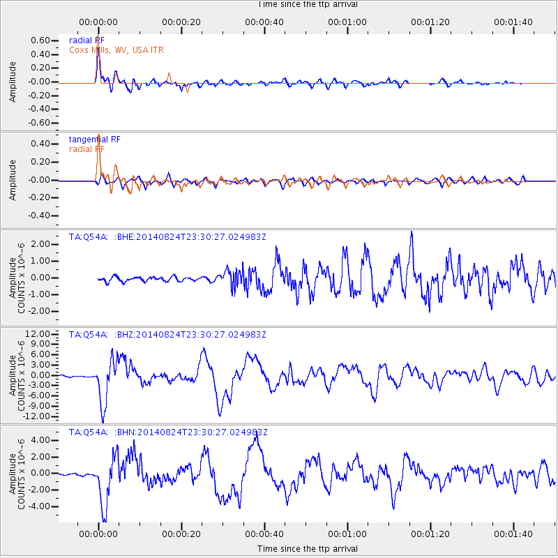
Signal To Noise
| Channel | StoN | STA | LTA |
| TA:Q54A: :BHZ:20140824T23:30:27.024983Z | 22.26032 | 6.4524925E-6 | 2.898652E-7 |
| TA:Q54A: :BHN:20140824T23:30:27.024983Z | 20.934153 | 3.049533E-6 | 1.4567263E-7 |
| TA:Q54A: :BHE:20140824T23:30:27.024983Z | 3.916201 | 4.884307E-7 | 1.2472054E-7 |
| Arrivals |
| Ps | 4.2 SECOND |
| PpPs | 16 SECOND |
| PsPs/PpSs | 20 SECOND |


