You are here: Home > Network List > TA - USArray Transportable Network (new EarthScope stations) Stations List
> Station G59A Clarenceville, QC, USA > Earthquake Result Viewer
G59A Clarenceville, QC, USA - Earthquake Result Viewer
| Earthquake location: |
Central Peru |
| Earthquake latitude/longitude: |
-14.6/-71.1 |
| Earthquake time(UTC): |
2015/04/21 (111) 19:00:17 GMT |
| Earthquake Depth: |
119 km |
| Earthquake Magnitude: |
5.6 MB |
| Earthquake Catalog/Contributor: |
NEIC PDE/NEIC COMCAT |
|
| Network: |
TA USArray Transportable Network (new EarthScope stations) |
| Station: |
G59A Clarenceville, QC, USA |
| Lat/Lon: |
45.08 N/73.18 W |
| Elevation: |
36 m |
|
| Distance: |
59.4 deg |
| Az: |
358.295 deg |
| Baz: |
177.67 deg |
| Ray Param: |
0.061845858 |
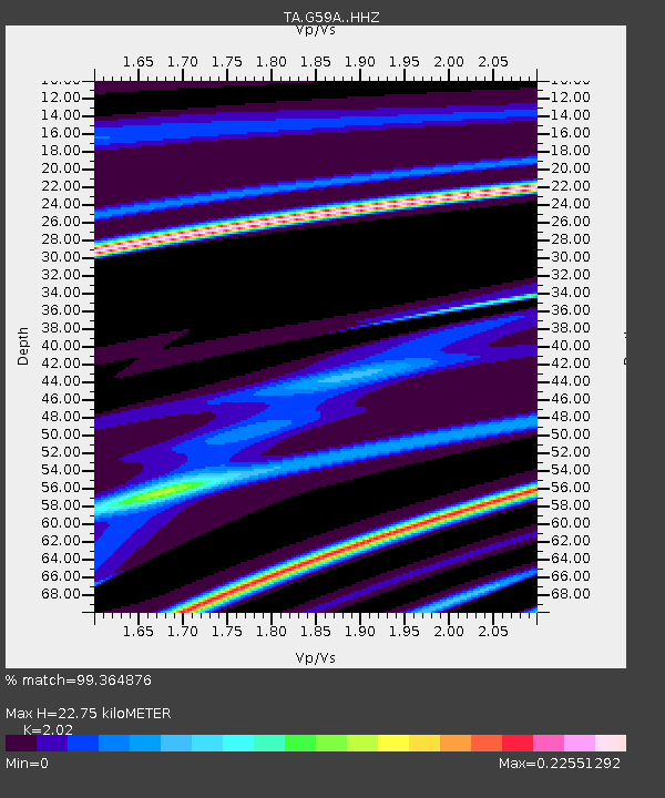
| Estimated Moho Depth: |
22.75 km |
| Estimated Crust Vp/Vs: |
2.02 |
| Assumed Crust Vp: |
6.419 km/s |
| Estimated Crust Vs: |
3.178 km/s |
| Estimated Crust Poisson's Ratio: |
0.34 |
|
| Radial Match: |
99.364876 % |
| Radial Bump: |
39 |
| Transverse Match: |
98.553444 % |
| Transverse Bump: |
60 |
| SOD ConfigId: |
7422571 |
| Insert Time: |
2019-04-18 07:30:49.450 +0000 |
| GWidth: |
2.5 |
| Max Bumps: |
400 |
| Tol: |
0.001 |
|

Signal To Noise
| Channel | StoN | STA | LTA |
| TA:G59A: :HHZ:20150421T19:09:38.45998Z | 1.4135838 | 2.4352244E-6 | 1.7227309E-6 |
| TA:G59A: :HHN:20150421T19:09:38.45998Z | 1.3721739 | 1.1190989E-5 | 8.155664E-6 |
| TA:G59A: :HHE:20150421T19:09:38.45998Z | 1.346339 | 1.8458932E-5 | 1.3710463E-5 |
| Arrivals |
| Ps | 3.8 SECOND |
| PpPs | 10 SECOND |
| PsPs/PpSs | 14 SECOND |


