You are here: Home > Network List > TA - USArray Transportable Network (new EarthScope stations) Stations List
> Station R59A King George, VA, USA > Earthquake Result Viewer
R59A King George, VA, USA - Earthquake Result Viewer
| Earthquake location: |
Central Peru |
| Earthquake latitude/longitude: |
-14.6/-73.6 |
| Earthquake time(UTC): |
2014/08/24 (236) 23:21:45 GMT |
| Earthquake Depth: |
101 km |
| Earthquake Magnitude: |
6.9 MWW, 6.8 MI, 6.9 MWB |
| Earthquake Catalog/Contributor: |
NEIC PDE/NEIC COMCAT |
|
| Network: |
TA USArray Transportable Network (new EarthScope stations) |
| Station: |
R59A King George, VA, USA |
| Lat/Lon: |
38.20 N/77.12 W |
| Elevation: |
35 m |
|
| Distance: |
52.6 deg |
| Az: |
356.491 deg |
| Baz: |
175.687 deg |
| Ray Param: |
0.066328034 |
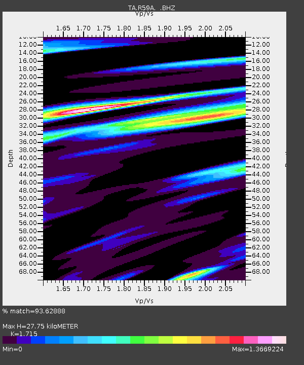
| Estimated Moho Depth: |
27.75 km |
| Estimated Crust Vp/Vs: |
1.72 |
| Assumed Crust Vp: |
6.419 km/s |
| Estimated Crust Vs: |
3.743 km/s |
| Estimated Crust Poisson's Ratio: |
0.24 |
|
| Radial Match: |
93.62888 % |
| Radial Bump: |
400 |
| Transverse Match: |
83.80599 % |
| Transverse Bump: |
400 |
| SOD ConfigId: |
769524 |
| Insert Time: |
2014-09-08 00:07:41.142 +0000 |
| GWidth: |
2.5 |
| Max Bumps: |
400 |
| Tol: |
0.001 |
|
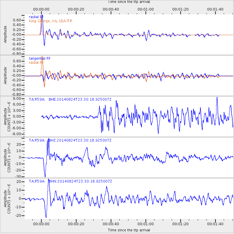
Signal To Noise
| Channel | StoN | STA | LTA |
| TA:R59A: :BHZ:20140824T23:30:18.925007Z | 68.37698 | 1.49460275E-5 | 2.1858273E-7 |
| TA:R59A: :BHN:20140824T23:30:18.925007Z | 22.509724 | 1.17317795E-5 | 5.211872E-7 |
| TA:R59A: :BHE:20140824T23:30:18.925007Z | 5.655581 | 2.4150215E-6 | 4.2701566E-7 |
| Arrivals |
| Ps | 3.3 SECOND |
| PpPs | 11 SECOND |
| PsPs/PpSs | 14 SECOND |


