You are here: Home > Network List > TA - USArray Transportable Network (new EarthScope stations) Stations List
> Station S56A Natural Bridge, VA, USA > Earthquake Result Viewer
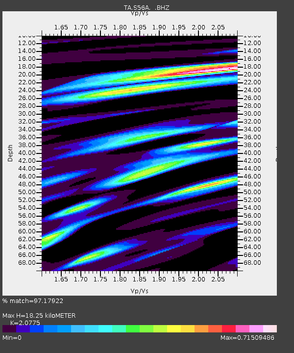
S56A Natural Bridge, VA, USA - Earthquake Result Viewer
| Earthquake location: |
Central Peru |
| Earthquake latitude/longitude: |
-14.6/-73.6 |
| Earthquake time(UTC): |
2014/08/24 (236) 23:21:45 GMT |
| Earthquake Depth: |
101 km |
| Earthquake Magnitude: |
6.9 MWW, 6.8 MI, 6.9 MWB |
| Earthquake Catalog/Contributor: |
NEIC PDE/NEIC COMCAT |
|
| Network: |
TA USArray Transportable Network (new EarthScope stations) |
| Station: |
S56A Natural Bridge, VA, USA |
| Lat/Lon: |
37.68 N/79.57 W |
| Elevation: |
449 m |
|
| Distance: |
52.3 deg |
| Az: |
353.994 deg |
| Baz: |
172.664 deg |
| Ray Param: |
0.066542365 |
| Estimated Moho Depth: |
18.25 km |
| Estimated Crust Vp/Vs: |
2.08 |
| Assumed Crust Vp: |
6.419 km/s |
| Estimated Crust Vs: |
3.09 km/s |
| Estimated Crust Poisson's Ratio: |
0.35 |
|
| Radial Match: |
97.17922 % |
| Radial Bump: |
333 |
| Transverse Match: |
83.026985 % |
| Transverse Bump: |
400 |
| SOD ConfigId: |
769524 |
| Insert Time: |
2014-09-08 00:07:58.452 +0000 |
| GWidth: |
2.5 |
| Max Bumps: |
400 |
| Tol: |
0.001 |
|

Signal To Noise
| Channel | StoN | STA | LTA |
| TA:S56A: :BHZ:20140824T23:30:16.525013Z | 58.263504 | 9.005732E-6 | 1.5456901E-7 |
| TA:S56A: :BHN:20140824T23:30:16.525013Z | 39.855022 | 4.975565E-6 | 1.248416E-7 |
| TA:S56A: :BHE:20140824T23:30:16.525013Z | 5.83231 | 7.1746445E-7 | 1.2301548E-7 |
| Arrivals |
| Ps | 3.2 SECOND |
| PpPs | 8.4 SECOND |
| PsPs/PpSs | 12 SECOND |


