You are here: Home > Network List > TA - USArray Transportable Network (new EarthScope stations) Stations List
> Station S57A Dark Hollow, Roseland, VA, USA > Earthquake Result Viewer
S57A Dark Hollow, Roseland, VA, USA - Earthquake Result Viewer
| Earthquake location: |
Central Peru |
| Earthquake latitude/longitude: |
-14.6/-73.6 |
| Earthquake time(UTC): |
2014/08/24 (236) 23:21:45 GMT |
| Earthquake Depth: |
101 km |
| Earthquake Magnitude: |
6.9 MWW, 6.8 MI, 6.9 MWB |
| Earthquake Catalog/Contributor: |
NEIC PDE/NEIC COMCAT |
|
| Network: |
TA USArray Transportable Network (new EarthScope stations) |
| Station: |
S57A Dark Hollow, Roseland, VA, USA |
| Lat/Lon: |
37.76 N/78.95 W |
| Elevation: |
264 m |
|
| Distance: |
52.3 deg |
| Az: |
354.616 deg |
| Baz: |
173.418 deg |
| Ray Param: |
0.06652716 |
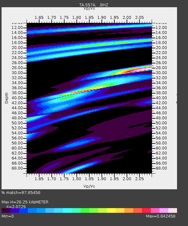
| Estimated Moho Depth: |
28.25 km |
| Estimated Crust Vp/Vs: |
2.07 |
| Assumed Crust Vp: |
6.419 km/s |
| Estimated Crust Vs: |
3.097 km/s |
| Estimated Crust Poisson's Ratio: |
0.35 |
|
| Radial Match: |
97.85458 % |
| Radial Bump: |
273 |
| Transverse Match: |
90.94954 % |
| Transverse Bump: |
400 |
| SOD ConfigId: |
769524 |
| Insert Time: |
2014-09-08 00:07:58.656 +0000 |
| GWidth: |
2.5 |
| Max Bumps: |
400 |
| Tol: |
0.001 |
|

Signal To Noise
| Channel | StoN | STA | LTA |
| TA:S57A: :BHZ:20140824T23:30:16.700001Z | 52.40294 | 9.784511E-6 | 1.8671685E-7 |
| TA:S57A: :BHN:20140824T23:30:16.700001Z | 44.142372 | 5.408147E-6 | 1.22516E-7 |
| TA:S57A: :BHE:20140824T23:30:16.700001Z | 7.8206306 | 9.5001565E-7 | 1.2147558E-7 |
| Arrivals |
| Ps | 4.9 SECOND |
| PpPs | 13 SECOND |
| PsPs/PpSs | 18 SECOND |


