You are here: Home > Network List > TA - USArray Transportable Network (new EarthScope stations) Stations List
> Station S58A Poland Farm, Powhatan, VA, USA > Earthquake Result Viewer
S58A Poland Farm, Powhatan, VA, USA - Earthquake Result Viewer
| Earthquake location: |
Central Peru |
| Earthquake latitude/longitude: |
-14.6/-73.6 |
| Earthquake time(UTC): |
2014/08/24 (236) 23:21:45 GMT |
| Earthquake Depth: |
101 km |
| Earthquake Magnitude: |
6.9 MWW, 6.8 MI, 6.9 MWB |
| Earthquake Catalog/Contributor: |
NEIC PDE/NEIC COMCAT |
|
| Network: |
TA USArray Transportable Network (new EarthScope stations) |
| Station: |
S58A Poland Farm, Powhatan, VA, USA |
| Lat/Lon: |
37.61 N/78.05 W |
| Elevation: |
96 m |
|
| Distance: |
52.1 deg |
| Az: |
355.497 deg |
| Baz: |
174.508 deg |
| Ray Param: |
0.066668436 |
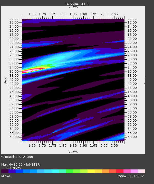
| Estimated Moho Depth: |
35.25 km |
| Estimated Crust Vp/Vs: |
1.65 |
| Assumed Crust Vp: |
6.419 km/s |
| Estimated Crust Vs: |
3.885 km/s |
| Estimated Crust Poisson's Ratio: |
0.21 |
|
| Radial Match: |
97.21365 % |
| Radial Bump: |
272 |
| Transverse Match: |
84.51792 % |
| Transverse Bump: |
400 |
| SOD ConfigId: |
769524 |
| Insert Time: |
2014-09-08 00:08:02.711 +0000 |
| GWidth: |
2.5 |
| Max Bumps: |
400 |
| Tol: |
0.001 |
|

Signal To Noise
| Channel | StoN | STA | LTA |
| TA:S58A: :BHZ:20140824T23:30:15.075001Z | 66.72317 | 1.020556E-5 | 1.5295377E-7 |
| TA:S58A: :BHN:20140824T23:30:15.075001Z | 44.739758 | 5.6322206E-6 | 1.2588849E-7 |
| TA:S58A: :BHE:20140824T23:30:15.075001Z | 5.771707 | 6.026787E-7 | 1.04419485E-7 |
| Arrivals |
| Ps | 3.8 SECOND |
| PpPs | 14 SECOND |
| PsPs/PpSs | 18 SECOND |


