You are here: Home > Network List > TA - USArray Transportable Network (new EarthScope stations) Stations List
> Station T56A Rocky Mt, VA, USA > Earthquake Result Viewer
T56A Rocky Mt, VA, USA - Earthquake Result Viewer
| Earthquake location: |
Central Peru |
| Earthquake latitude/longitude: |
-14.6/-73.6 |
| Earthquake time(UTC): |
2014/08/24 (236) 23:21:45 GMT |
| Earthquake Depth: |
101 km |
| Earthquake Magnitude: |
6.9 MWW, 6.8 MI, 6.9 MWB |
| Earthquake Catalog/Contributor: |
NEIC PDE/NEIC COMCAT |
|
| Network: |
TA USArray Transportable Network (new EarthScope stations) |
| Station: |
T56A Rocky Mt, VA, USA |
| Lat/Lon: |
37.03 N/80.03 W |
| Elevation: |
387 m |
|
| Distance: |
51.7 deg |
| Az: |
353.418 deg |
| Baz: |
172.029 deg |
| Ray Param: |
0.06691867 |
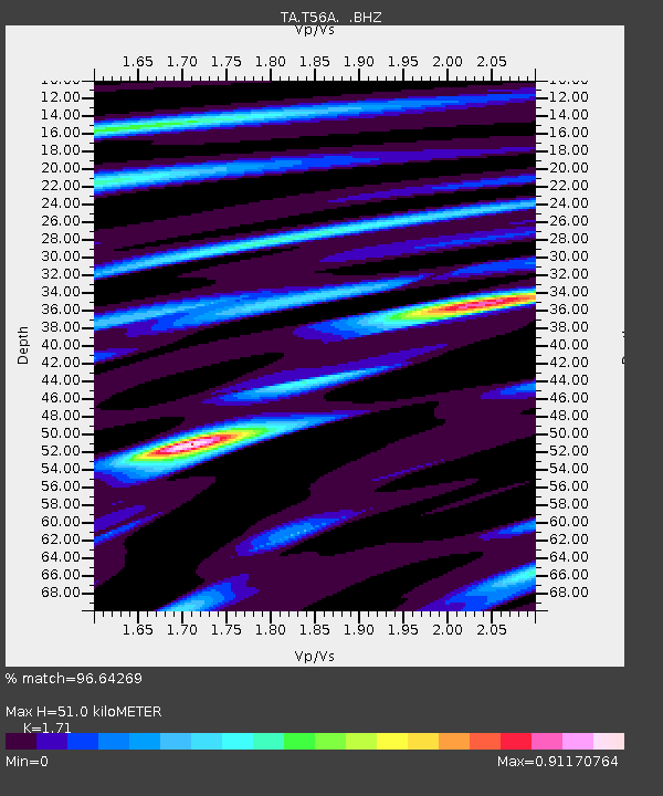
| Estimated Moho Depth: |
51.0 km |
| Estimated Crust Vp/Vs: |
1.71 |
| Assumed Crust Vp: |
6.159 km/s |
| Estimated Crust Vs: |
3.602 km/s |
| Estimated Crust Poisson's Ratio: |
0.24 |
|
| Radial Match: |
96.64269 % |
| Radial Bump: |
258 |
| Transverse Match: |
90.785164 % |
| Transverse Bump: |
400 |
| SOD ConfigId: |
769524 |
| Insert Time: |
2014-09-08 00:08:25.565 +0000 |
| GWidth: |
2.5 |
| Max Bumps: |
400 |
| Tol: |
0.001 |
|
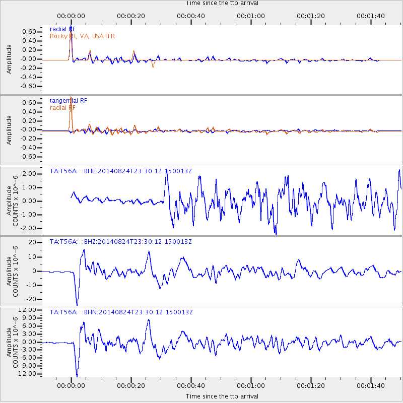
Signal To Noise
| Channel | StoN | STA | LTA |
| TA:T56A: :BHZ:20140824T23:30:12.150013Z | 76.79791 | 1.1241953E-5 | 1.4638358E-7 |
| TA:T56A: :BHN:20140824T23:30:12.150013Z | 23.304495 | 5.8285837E-6 | 2.5010556E-7 |
| TA:T56A: :BHE:20140824T23:30:12.150013Z | 6.56434 | 1.1009209E-6 | 1.6771236E-7 |
| Arrivals |
| Ps | 6.2 SECOND |
| PpPs | 21 SECOND |
| PsPs/PpSs | 27 SECOND |


