You are here: Home > Network List > TA - USArray Transportable Network (new EarthScope stations) Stations List
> Station U57A Blanch, NC, USA > Earthquake Result Viewer
U57A Blanch, NC, USA - Earthquake Result Viewer
| Earthquake location: |
Central Peru |
| Earthquake latitude/longitude: |
-14.6/-73.6 |
| Earthquake time(UTC): |
2014/08/24 (236) 23:21:45 GMT |
| Earthquake Depth: |
101 km |
| Earthquake Magnitude: |
6.9 MWW, 6.8 MI, 6.9 MWB |
| Earthquake Catalog/Contributor: |
NEIC PDE/NEIC COMCAT |
|
| Network: |
TA USArray Transportable Network (new EarthScope stations) |
| Station: |
U57A Blanch, NC, USA |
| Lat/Lon: |
36.43 N/79.34 W |
| Elevation: |
178 m |
|
| Distance: |
51.0 deg |
| Az: |
354.026 deg |
| Baz: |
172.822 deg |
| Ray Param: |
0.06735578 |
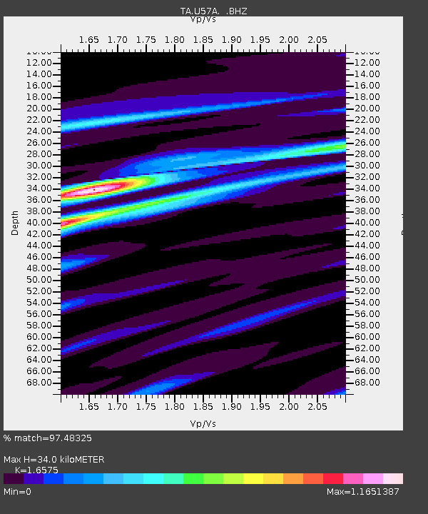
| Estimated Moho Depth: |
34.0 km |
| Estimated Crust Vp/Vs: |
1.66 |
| Assumed Crust Vp: |
6.419 km/s |
| Estimated Crust Vs: |
3.873 km/s |
| Estimated Crust Poisson's Ratio: |
0.21 |
|
| Radial Match: |
97.48325 % |
| Radial Bump: |
275 |
| Transverse Match: |
87.464584 % |
| Transverse Bump: |
400 |
| SOD ConfigId: |
769524 |
| Insert Time: |
2014-09-08 00:08:56.395 +0000 |
| GWidth: |
2.5 |
| Max Bumps: |
400 |
| Tol: |
0.001 |
|
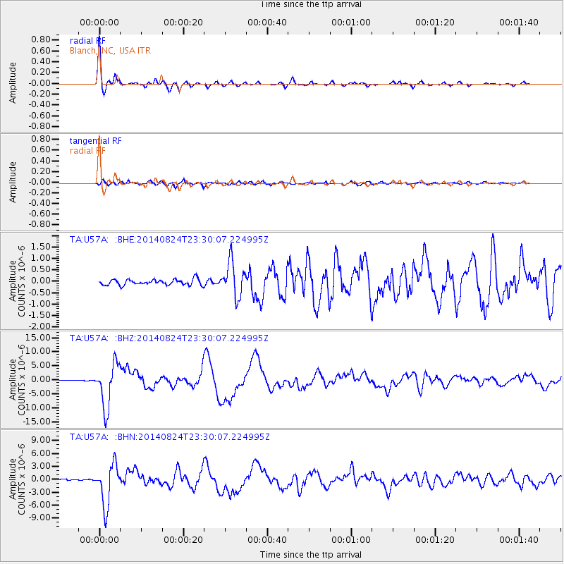
Signal To Noise
| Channel | StoN | STA | LTA |
| TA:U57A: :BHZ:20140824T23:30:07.224995Z | 64.18708 | 8.136447E-6 | 1.2676145E-7 |
| TA:U57A: :BHN:20140824T23:30:07.224995Z | 51.454773 | 4.983686E-6 | 9.685566E-8 |
| TA:U57A: :BHE:20140824T23:30:07.224995Z | 6.2779245 | 7.7767777E-7 | 1.2387498E-7 |
| Arrivals |
| Ps | 3.7 SECOND |
| PpPs | 13 SECOND |
| PsPs/PpSs | 17 SECOND |


