You are here: Home > Network List > TA - USArray Transportable Network (new EarthScope stations) Stations List
> Station W59A Clinton, NC, USA > Earthquake Result Viewer
W59A Clinton, NC, USA - Earthquake Result Viewer
| Earthquake location: |
Central Peru |
| Earthquake latitude/longitude: |
-14.6/-73.6 |
| Earthquake time(UTC): |
2014/08/24 (236) 23:21:45 GMT |
| Earthquake Depth: |
101 km |
| Earthquake Magnitude: |
6.9 MWW, 6.8 MI, 6.9 MWB |
| Earthquake Catalog/Contributor: |
NEIC PDE/NEIC COMCAT |
|
| Network: |
TA USArray Transportable Network (new EarthScope stations) |
| Station: |
W59A Clinton, NC, USA |
| Lat/Lon: |
35.17 N/78.44 W |
| Elevation: |
60 m |
|
| Distance: |
49.7 deg |
| Az: |
354.772 deg |
| Baz: |
173.819 deg |
| Ray Param: |
0.0682153 |
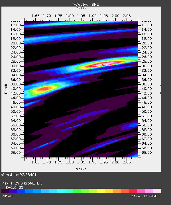
| Estimated Moho Depth: |
29.0 km |
| Estimated Crust Vp/Vs: |
1.94 |
| Assumed Crust Vp: |
6.565 km/s |
| Estimated Crust Vs: |
3.379 km/s |
| Estimated Crust Poisson's Ratio: |
0.32 |
|
| Radial Match: |
93.85491 % |
| Radial Bump: |
294 |
| Transverse Match: |
79.52972 % |
| Transverse Bump: |
400 |
| SOD ConfigId: |
769524 |
| Insert Time: |
2014-09-08 00:09:40.811 +0000 |
| GWidth: |
2.5 |
| Max Bumps: |
400 |
| Tol: |
0.001 |
|

Signal To Noise
| Channel | StoN | STA | LTA |
| TA:W59A: :BHZ:20140824T23:29:57.150013Z | 33.469524 | 1.0531816E-5 | 3.1466882E-7 |
| TA:W59A: :BHN:20140824T23:29:57.150013Z | 24.77813 | 7.0432275E-6 | 2.8425177E-7 |
| TA:W59A: :BHE:20140824T23:29:57.150013Z | 5.9169245 | 1.6304678E-6 | 2.7556E-7 |
| Arrivals |
| Ps | 4.4 SECOND |
| PpPs | 12 SECOND |
| PsPs/PpSs | 17 SECOND |


