You are here: Home > Network List > TA - USArray Transportable Network (new EarthScope stations) Stations List
> Station W61A Ground Anchor Farm, New Bern, NC, USA > Earthquake Result Viewer
W61A Ground Anchor Farm, New Bern, NC, USA - Earthquake Result Viewer
| Earthquake location: |
Central Peru |
| Earthquake latitude/longitude: |
-14.6/-73.6 |
| Earthquake time(UTC): |
2014/08/24 (236) 23:21:45 GMT |
| Earthquake Depth: |
101 km |
| Earthquake Magnitude: |
6.9 MWW, 6.8 MI, 6.9 MWB |
| Earthquake Catalog/Contributor: |
NEIC PDE/NEIC COMCAT |
|
| Network: |
TA USArray Transportable Network (new EarthScope stations) |
| Station: |
W61A Ground Anchor Farm, New Bern, NC, USA |
| Lat/Lon: |
35.18 N/76.99 W |
| Elevation: |
6.0 m |
|
| Distance: |
49.6 deg |
| Az: |
356.328 deg |
| Baz: |
175.659 deg |
| Ray Param: |
0.06827827 |
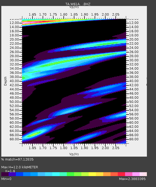
| Estimated Moho Depth: |
12.0 km |
| Estimated Crust Vp/Vs: |
1.60 |
| Assumed Crust Vp: |
6.565 km/s |
| Estimated Crust Vs: |
4.103 km/s |
| Estimated Crust Poisson's Ratio: |
0.18 |
|
| Radial Match: |
97.12835 % |
| Radial Bump: |
381 |
| Transverse Match: |
78.004585 % |
| Transverse Bump: |
400 |
| SOD ConfigId: |
769524 |
| Insert Time: |
2014-09-08 00:09:45.398 +0000 |
| GWidth: |
2.5 |
| Max Bumps: |
400 |
| Tol: |
0.001 |
|
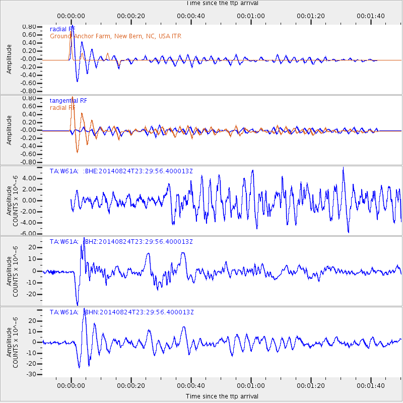
Signal To Noise
| Channel | StoN | STA | LTA |
| TA:W61A: :BHZ:20140824T23:29:56.400013Z | 27.958267 | 1.4857354E-5 | 5.3141184E-7 |
| TA:W61A: :BHN:20140824T23:29:56.400013Z | 15.770514 | 1.4552914E-5 | 9.2279265E-7 |
| TA:W61A: :BHE:20140824T23:29:56.400013Z | 2.5713553 | 2.070648E-6 | 8.0527496E-7 |
| Arrivals |
| Ps | 1.2 SECOND |
| PpPs | 4.4 SECOND |
| PsPs/PpSs | 5.6 SECOND |


