You are here: Home > Network List > TA - USArray Transportable Network (new EarthScope stations) Stations List
> Station X40A Basin Creek Farm, Marlvern, AR, USA > Earthquake Result Viewer
X40A Basin Creek Farm, Marlvern, AR, USA - Earthquake Result Viewer
| Earthquake location: |
Central Peru |
| Earthquake latitude/longitude: |
-14.6/-73.6 |
| Earthquake time(UTC): |
2014/08/24 (236) 23:21:45 GMT |
| Earthquake Depth: |
101 km |
| Earthquake Magnitude: |
6.9 MWW, 6.8 MI, 6.9 MWB |
| Earthquake Catalog/Contributor: |
NEIC PDE/NEIC COMCAT |
|
| Network: |
TA USArray Transportable Network (new EarthScope stations) |
| Station: |
X40A Basin Creek Farm, Marlvern, AR, USA |
| Lat/Lon: |
34.49 N/92.83 W |
| Elevation: |
158 m |
|
| Distance: |
52.1 deg |
| Az: |
339.811 deg |
| Baz: |
156.14 deg |
| Ray Param: |
0.066645846 |
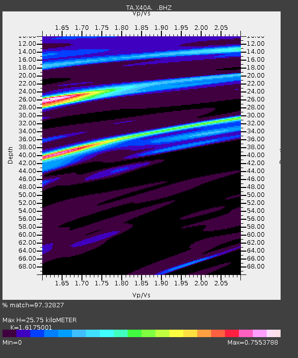
| Estimated Moho Depth: |
25.75 km |
| Estimated Crust Vp/Vs: |
1.62 |
| Assumed Crust Vp: |
6.498 km/s |
| Estimated Crust Vs: |
4.017 km/s |
| Estimated Crust Poisson's Ratio: |
0.19 |
|
| Radial Match: |
97.32827 % |
| Radial Bump: |
266 |
| Transverse Match: |
92.50345 % |
| Transverse Bump: |
400 |
| SOD ConfigId: |
769524 |
| Insert Time: |
2014-09-08 00:09:49.702 +0000 |
| GWidth: |
2.5 |
| Max Bumps: |
400 |
| Tol: |
0.001 |
|

Signal To Noise
| Channel | StoN | STA | LTA |
| TA:X40A: :BHZ:20140824T23:30:15.325001Z | 108.054924 | 9.792661E-6 | 9.06267E-8 |
| TA:X40A: :BHN:20140824T23:30:15.325001Z | 30.1784 | 2.3762102E-6 | 7.873878E-8 |
| TA:X40A: :BHE:20140824T23:30:15.325001Z | 41.004917 | 2.720043E-6 | 6.633456E-8 |
| Arrivals |
| Ps | 2.6 SECOND |
| PpPs | 9.7 SECOND |
| PsPs/PpSs | 12 SECOND |


