You are here: Home > Network List > TA - USArray Transportable Network (new EarthScope stations) Stations List
> Station X59A McDuffie Farm, Elizabethtown, NC, USA > Earthquake Result Viewer
X59A McDuffie Farm, Elizabethtown, NC, USA - Earthquake Result Viewer
| Earthquake location: |
Central Peru |
| Earthquake latitude/longitude: |
-14.6/-73.6 |
| Earthquake time(UTC): |
2014/08/24 (236) 23:21:45 GMT |
| Earthquake Depth: |
101 km |
| Earthquake Magnitude: |
6.9 MWW, 6.8 MI, 6.9 MWB |
| Earthquake Catalog/Contributor: |
NEIC PDE/NEIC COMCAT |
|
| Network: |
TA USArray Transportable Network (new EarthScope stations) |
| Station: |
X59A McDuffie Farm, Elizabethtown, NC, USA |
| Lat/Lon: |
34.57 N/78.60 W |
| Elevation: |
29 m |
|
| Distance: |
49.1 deg |
| Az: |
354.515 deg |
| Baz: |
173.56 deg |
| Ray Param: |
0.068579346 |
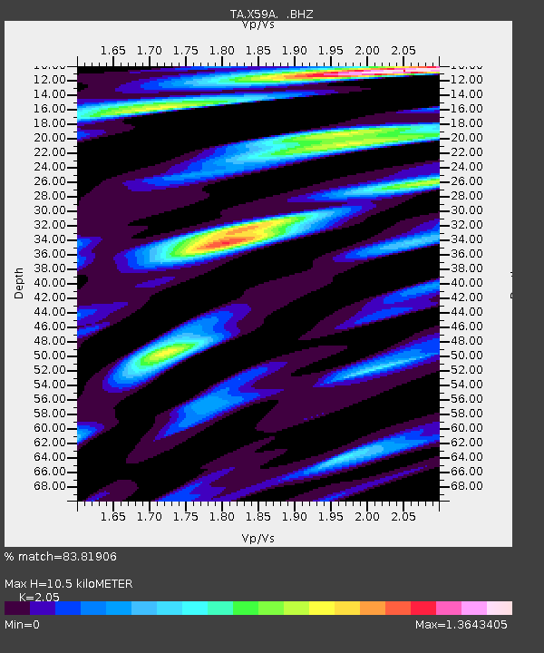
| Estimated Moho Depth: |
10.5 km |
| Estimated Crust Vp/Vs: |
2.05 |
| Assumed Crust Vp: |
6.565 km/s |
| Estimated Crust Vs: |
3.202 km/s |
| Estimated Crust Poisson's Ratio: |
0.34 |
|
| Radial Match: |
83.81906 % |
| Radial Bump: |
400 |
| Transverse Match: |
65.29397 % |
| Transverse Bump: |
400 |
| SOD ConfigId: |
769524 |
| Insert Time: |
2014-09-08 00:10:07.018 +0000 |
| GWidth: |
2.5 |
| Max Bumps: |
400 |
| Tol: |
0.001 |
|
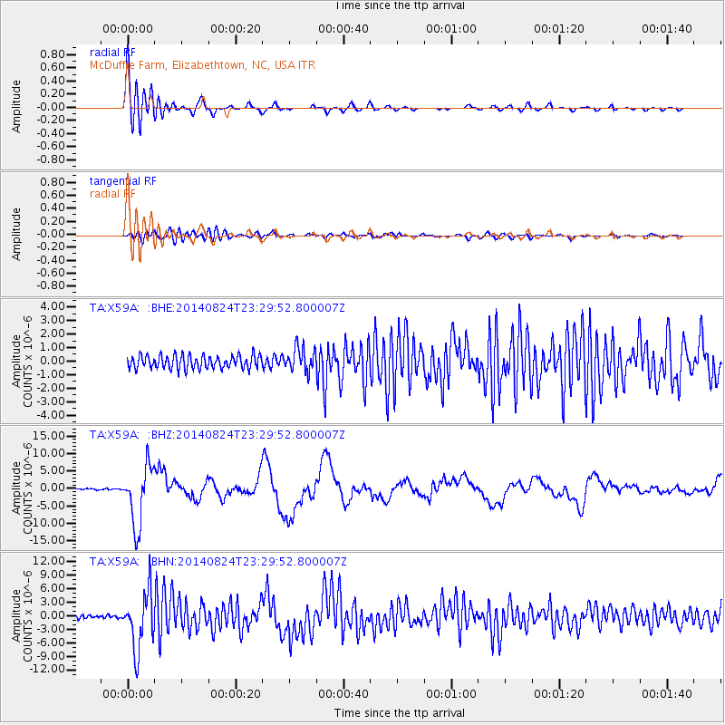
Signal To Noise
| Channel | StoN | STA | LTA |
| TA:X59A: :BHZ:20140824T23:29:52.800007Z | 34.699432 | 8.527463E-6 | 2.4575226E-7 |
| TA:X59A: :BHN:20140824T23:29:52.800007Z | 13.092966 | 6.3259836E-6 | 4.8315894E-7 |
| TA:X59A: :BHE:20140824T23:29:52.800007Z | 1.8484249 | 8.866542E-7 | 4.796809E-7 |
| Arrivals |
| Ps | 1.8 SECOND |
| PpPs | 4.6 SECOND |
| PsPs/PpSs | 6.4 SECOND |


