You are here: Home > Network List > TA - USArray Transportable Network (new EarthScope stations) Stations List
> Station X60A Albert Glenn Thornton, NC, USA > Earthquake Result Viewer
X60A Albert Glenn Thornton, NC, USA - Earthquake Result Viewer
| Earthquake location: |
Central Peru |
| Earthquake latitude/longitude: |
-14.6/-73.6 |
| Earthquake time(UTC): |
2014/08/24 (236) 23:21:45 GMT |
| Earthquake Depth: |
101 km |
| Earthquake Magnitude: |
6.9 MWW, 6.8 MI, 6.9 MWB |
| Earthquake Catalog/Contributor: |
NEIC PDE/NEIC COMCAT |
|
| Network: |
TA USArray Transportable Network (new EarthScope stations) |
| Station: |
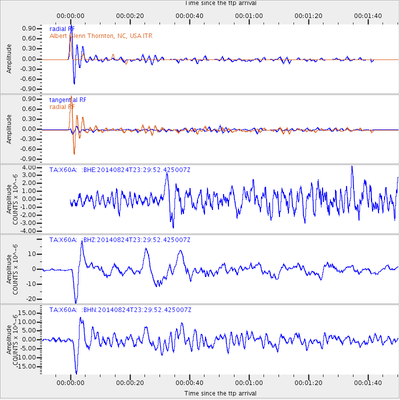
X60A Albert Glenn Thornton, NC, USA |
| Lat/Lon: |
34.58 N/77.98 W |
| Elevation: |
12 m |
|
| Distance: |
49.1 deg |
| Az: |
355.195 deg |
| Baz: |
174.359 deg |
| Ray Param: |
0.068610325 |
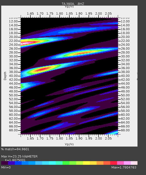
| Estimated Moho Depth: |
23.25 km |
| Estimated Crust Vp/Vs: |
1.61 |
| Assumed Crust Vp: |
6.565 km/s |
| Estimated Crust Vs: |
4.084 km/s |
| Estimated Crust Poisson's Ratio: |
0.18 |
|
| Radial Match: |
94.9601 % |
| Radial Bump: |
400 |
| Transverse Match: |
70.14346 % |
| Transverse Bump: |
400 |
| SOD ConfigId: |
769524 |
| Insert Time: |
2014-09-08 00:10:07.741 +0000 |
| GWidth: |
2.5 |
| Max Bumps: |
400 |
| Tol: |
0.001 |
|
Signal To Noise
| Channel | StoN | STA | LTA |
| TA:X60A: :BHZ:20140824T23:29:52.425007Z | 33.716908 | 1.1666527E-5 | 3.4601413E-7 |
| TA:X60A: :BHN:20140824T23:29:52.425007Z | 16.181456 | 8.968491E-6 | 5.54245E-7 |
| TA:X60A: :BHE:20140824T23:29:52.425007Z | 3.0822542 | 1.8419488E-6 | 5.9759793E-7 |
| Arrivals |
| Ps | 2.3 SECOND |
| PpPs | 8.6 SECOND |
| PsPs/PpSs | 11 SECOND |


