You are here: Home > Network List > TA - USArray Transportable Network (new EarthScope stations) Stations List
> Station Y56A Pelion, SC, USA > Earthquake Result Viewer
Y56A Pelion, SC, USA - Earthquake Result Viewer
| Earthquake location: |
Central Peru |
| Earthquake latitude/longitude: |
-14.6/-73.6 |
| Earthquake time(UTC): |
2014/08/24 (236) 23:21:45 GMT |
| Earthquake Depth: |
101 km |
| Earthquake Magnitude: |
6.9 MWW, 6.8 MI, 6.9 MWB |
| Earthquake Catalog/Contributor: |
NEIC PDE/NEIC COMCAT |
|
| Network: |
TA USArray Transportable Network (new EarthScope stations) |
| Station: |
Y56A Pelion, SC, USA |
| Lat/Lon: |
33.79 N/81.30 W |
| Elevation: |
154 m |
|
| Distance: |
48.7 deg |
| Az: |
351.424 deg |
| Baz: |
170.017 deg |
| Ray Param: |
0.06886495 |
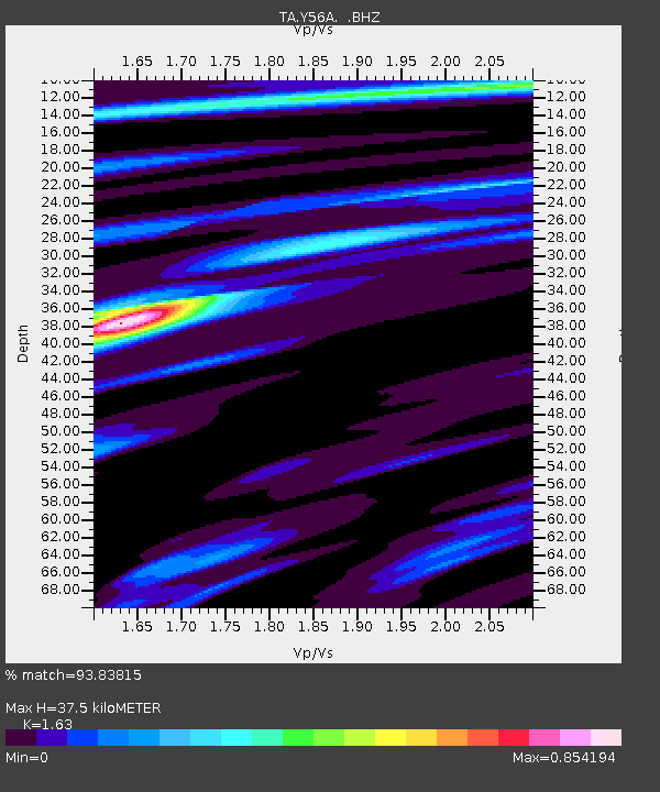
| Estimated Moho Depth: |
37.5 km |
| Estimated Crust Vp/Vs: |
1.63 |
| Assumed Crust Vp: |
6.565 km/s |
| Estimated Crust Vs: |
4.027 km/s |
| Estimated Crust Poisson's Ratio: |
0.20 |
|
| Radial Match: |
93.83815 % |
| Radial Bump: |
312 |
| Transverse Match: |
68.29968 % |
| Transverse Bump: |
400 |
| SOD ConfigId: |
769524 |
| Insert Time: |
2014-09-08 00:10:16.672 +0000 |
| GWidth: |
2.5 |
| Max Bumps: |
400 |
| Tol: |
0.001 |
|
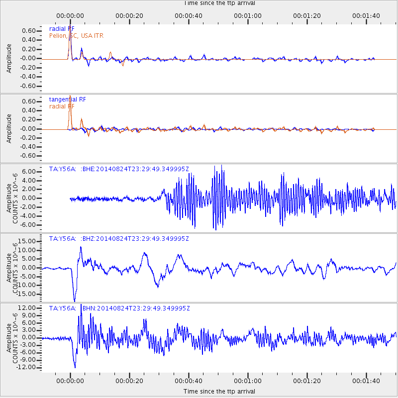
Signal To Noise
| Channel | StoN | STA | LTA |
| TA:Y56A: :BHZ:20140824T23:29:49.349995Z | 40.967182 | 8.581219E-6 | 2.0946568E-7 |
| TA:Y56A: :BHN:20140824T23:29:49.349995Z | 23.536772 | 5.789489E-6 | 2.4597634E-7 |
| TA:Y56A: :BHE:20140824T23:29:49.349995Z | 5.123199 | 1.2052419E-6 | 2.3525183E-7 |
| Arrivals |
| Ps | 3.9 SECOND |
| PpPs | 14 SECOND |
| PsPs/PpSs | 18 SECOND |


