You are here: Home > Network List > TA - USArray Transportable Network (new EarthScope stations) Stations List
> Station Z57A Bowman, SC, USA > Earthquake Result Viewer
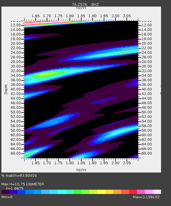
Z57A Bowman, SC, USA - Earthquake Result Viewer
| Earthquake location: |
Central Peru |
| Earthquake latitude/longitude: |
-14.6/-73.6 |
| Earthquake time(UTC): |
2014/08/24 (236) 23:21:45 GMT |
| Earthquake Depth: |
101 km |
| Earthquake Magnitude: |
6.9 MWW, 6.8 MI, 6.9 MWB |
| Earthquake Catalog/Contributor: |
NEIC PDE/NEIC COMCAT |
|
| Network: |
TA USArray Transportable Network (new EarthScope stations) |
| Station: |
Z57A Bowman, SC, USA |
| Lat/Lon: |
33.30 N/80.70 W |
| Elevation: |
81 m |
|
| Distance: |
48.1 deg |
| Az: |
351.976 deg |
| Baz: |
170.713 deg |
| Ray Param: |
0.06924419 |
| Estimated Moho Depth: |
10.75 km |
| Estimated Crust Vp/Vs: |
1.67 |
| Assumed Crust Vp: |
6.565 km/s |
| Estimated Crust Vs: |
3.937 km/s |
| Estimated Crust Poisson's Ratio: |
0.22 |
|
| Radial Match: |
93.90404 % |
| Radial Bump: |
399 |
| Transverse Match: |
77.918495 % |
| Transverse Bump: |
400 |
| SOD ConfigId: |
769524 |
| Insert Time: |
2014-09-08 00:10:32.133 +0000 |
| GWidth: |
2.5 |
| Max Bumps: |
400 |
| Tol: |
0.001 |
|

Signal To Noise
| Channel | StoN | STA | LTA |
| TA:Z57A: :BHZ:20140824T23:29:44.999989Z | 34.384037 | 9.649003E-6 | 2.8062448E-7 |
| TA:Z57A: :BHN:20140824T23:29:44.999989Z | 10.215017 | 8.504214E-6 | 8.325207E-7 |
| TA:Z57A: :BHE:20140824T23:29:44.999989Z | 2.3089125 | 1.655674E-6 | 7.170796E-7 |
| Arrivals |
| Ps | 1.2 SECOND |
| PpPs | 4.1 SECOND |
| PsPs/PpSs | 5.3 SECOND |


