You are here: Home > Network List > US - United States National Seismic Network Stations List
> Station SDCO Great Sand Dunes National Park, Colorado, USA > Earthquake Result Viewer
SDCO Great Sand Dunes National Park, Colorado, USA - Earthquake Result Viewer
| Earthquake location: |
Central Peru |
| Earthquake latitude/longitude: |
-14.6/-73.6 |
| Earthquake time(UTC): |
2014/08/24 (236) 23:21:45 GMT |
| Earthquake Depth: |
101 km |
| Earthquake Magnitude: |
6.9 MWW, 6.8 MI, 6.9 MWB |
| Earthquake Catalog/Contributor: |
NEIC PDE/NEIC COMCAT |
|
| Network: |
US United States National Seismic Network |
| Station: |
SDCO Great Sand Dunes National Park, Colorado, USA |
| Lat/Lon: |
37.75 N/105.50 W |
| Elevation: |
2569 m |
|
| Distance: |
60.1 deg |
| Az: |
331.075 deg |
| Baz: |
143.792 deg |
| Ray Param: |
0.061481223 |
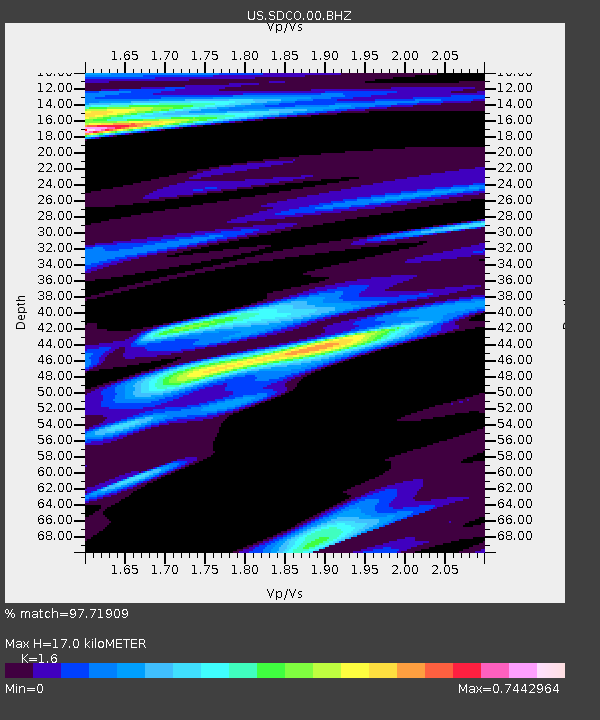
| Estimated Moho Depth: |
17.0 km |
| Estimated Crust Vp/Vs: |
1.60 |
| Assumed Crust Vp: |
6.316 km/s |
| Estimated Crust Vs: |
3.947 km/s |
| Estimated Crust Poisson's Ratio: |
0.18 |
|
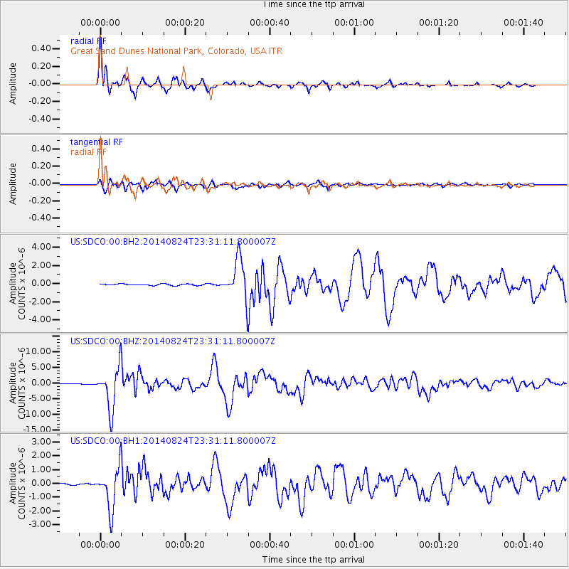
| Radial Match: |
97.71909 % |
| Radial Bump: |
320 |
| Transverse Match: |
94.04936 % |
| Transverse Bump: |
400 |
| SOD ConfigId: |
769524 |
| Insert Time: |
2014-09-08 00:12:53.468 +0000 |
| GWidth: |
2.5 |
| Max Bumps: |
400 |
| Tol: |
0.001 |
|
Signal To Noise
| Channel | StoN | STA | LTA |
| US:SDCO:00:BHZ:20140824T23:31:11.800007Z | 79.58937 | 6.99758E-6 | 8.792103E-8 |
| US:SDCO:00:BH1:20140824T23:31:11.800007Z | 22.517345 | 1.5802576E-6 | 7.0179574E-8 |
| US:SDCO:00:BH2:20140824T23:31:11.800007Z | 28.707605 | 2.291214E-6 | 7.981209E-8 |
| Arrivals |
| Ps | 1.7 SECOND |
| PpPs | 6.7 SECOND |
| PsPs/PpSs | 8.4 SECOND |


