You are here: Home > Network List > US - United States National Seismic Network Stations List
> Station TZTN Tazewell, Tennessee, USA > Earthquake Result Viewer
TZTN Tazewell, Tennessee, USA - Earthquake Result Viewer
| Earthquake location: |
Central Peru |
| Earthquake latitude/longitude: |
-14.6/-73.6 |
| Earthquake time(UTC): |
2014/08/24 (236) 23:21:45 GMT |
| Earthquake Depth: |
101 km |
| Earthquake Magnitude: |
6.9 MWW, 6.8 MI, 6.9 MWB |
| Earthquake Catalog/Contributor: |
NEIC PDE/NEIC COMCAT |
|
| Network: |
US United States National Seismic Network |
| Station: |
TZTN Tazewell, Tennessee, USA |
| Lat/Lon: |
36.54 N/83.55 W |
| Elevation: |
394 m |
|
| Distance: |
51.7 deg |
| Az: |
349.768 deg |
| Baz: |
167.668 deg |
| Ray Param: |
0.066905 |
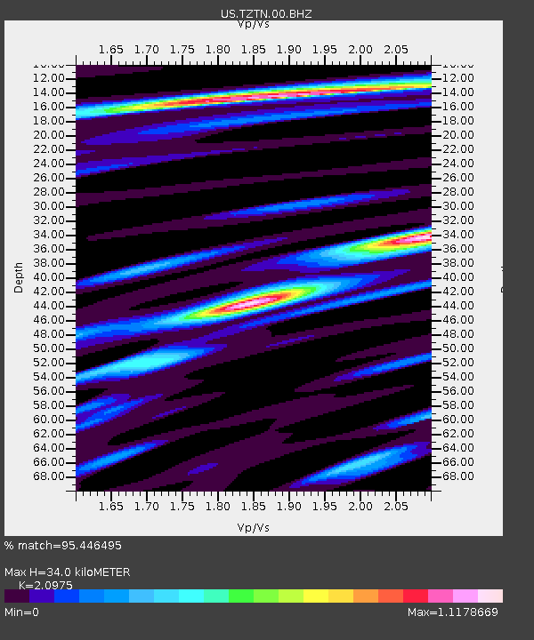
| Estimated Moho Depth: |
34.0 km |
| Estimated Crust Vp/Vs: |
2.10 |
| Assumed Crust Vp: |
6.476 km/s |
| Estimated Crust Vs: |
3.087 km/s |
| Estimated Crust Poisson's Ratio: |
0.35 |
|
| Radial Match: |
95.446495 % |
| Radial Bump: |
400 |
| Transverse Match: |
84.53635 % |
| Transverse Bump: |
400 |
| SOD ConfigId: |
769524 |
| Insert Time: |
2014-09-08 00:12:57.925 +0000 |
| GWidth: |
2.5 |
| Max Bumps: |
400 |
| Tol: |
0.001 |
|

Signal To Noise
| Channel | StoN | STA | LTA |
| US:TZTN:00:BHZ:20140824T23:30:12.325001Z | 50.36298 | 9.228348E-6 | 1.8323674E-7 |
| US:TZTN:00:BH1:20140824T23:30:12.325001Z | 39.43165 | 4.1392514E-6 | 1.0497283E-7 |
| US:TZTN:00:BH2:20140824T23:30:12.325001Z | 7.7212296 | 7.029948E-7 | 9.1047E-8 |
| Arrivals |
| Ps | 6.0 SECOND |
| PpPs | 16 SECOND |
| PsPs/PpSs | 22 SECOND |


