You are here: Home > Network List > AV - Alaska Volcano Observatory Stations List
> Station MAPS Pakushin Southeast, Makushin Volcano, Alaska > Earthquake Result Viewer
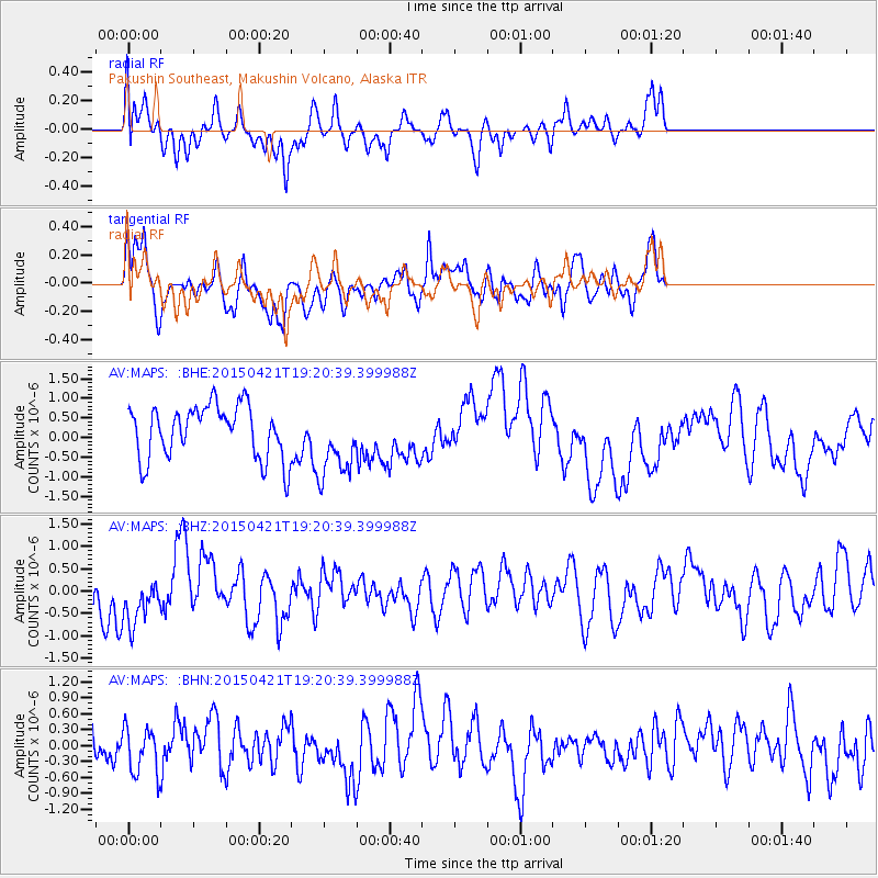
MAPS Pakushin Southeast, Makushin Volcano, Alaska - Earthquake Result Viewer
*The percent match for this event was below the threshold and hence no stack was calculated.
| Earthquake location: |
Solomon Islands |
| Earthquake latitude/longitude: |
-6.4/154.8 |
| Earthquake time(UTC): |
2015/04/21 (111) 19:10:17 GMT |
| Earthquake Depth: |
63 km |
| Earthquake Magnitude: |
5.4 MW, 5.4 mb |
| Earthquake Catalog/Contributor: |
ISC/ISC |
|
| Network: |
AV Alaska Volcano Observatory |
| Station: |
MAPS Pakushin Southeast, Makushin Volcano, Alaska |
| Lat/Lon: |
53.81 N/166.94 W |
| Elevation: |
333 m |
|
| Distance: |
68.0 deg |
| Az: |
23.316 deg |
| Baz: |
221.555 deg |
| Ray Param: |
$rayparam |
*The percent match for this event was below the threshold and hence was not used in the summary stack. |
|
| Radial Match: |
51.07468 % |
| Radial Bump: |
400 |
| Transverse Match: |
55.988316 % |
| Transverse Bump: |
400 |
| SOD ConfigId: |
7422571 |
| Insert Time: |
2019-04-18 07:34:04.722 +0000 |
| GWidth: |
2.5 |
| Max Bumps: |
400 |
| Tol: |
0.001 |
|
Signal To Noise
| Channel | StoN | STA | LTA |
| AV:MAPS: :BHZ:20150421T19:20:39.399988Z | 1.1994686 | 5.877789E-7 | 4.900328E-7 |
| AV:MAPS: :BHN:20150421T19:20:39.399988Z | 0.83793956 | 4.4709398E-7 | 5.3356354E-7 |
| AV:MAPS: :BHE:20150421T19:20:39.399988Z | 1.3916588 | 9.3545475E-7 | 6.721869E-7 |
| Arrivals |
| Ps | |
| PpPs | |
| PsPs/PpSs | |


