You are here: Home > Network List > UW - Pacific Northwest Regional Seismic Network Stations List
> Station LEBA Lebam, WA, USA > Earthquake Result Viewer
LEBA Lebam, WA, USA - Earthquake Result Viewer
| Earthquake location: |
Central Peru |
| Earthquake latitude/longitude: |
-14.6/-73.6 |
| Earthquake time(UTC): |
2014/08/24 (236) 23:21:45 GMT |
| Earthquake Depth: |
101 km |
| Earthquake Magnitude: |
6.9 MWW, 6.8 MI, 6.9 MWB |
| Earthquake Catalog/Contributor: |
NEIC PDE/NEIC COMCAT |
|
| Network: |
UW Pacific Northwest Regional Seismic Network |
| Station: |
LEBA Lebam, WA, USA |
| Lat/Lon: |
46.55 N/123.56 W |
| Elevation: |
73 m |
|
| Distance: |
75.6 deg |
| Az: |
326.924 deg |
| Baz: |
130.045 deg |
| Ray Param: |
0.051317263 |
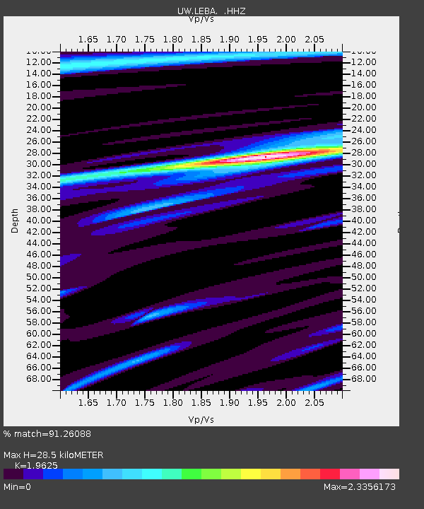
| Estimated Moho Depth: |
28.5 km |
| Estimated Crust Vp/Vs: |
1.96 |
| Assumed Crust Vp: |
6.566 km/s |
| Estimated Crust Vs: |
3.346 km/s |
| Estimated Crust Poisson's Ratio: |
0.32 |
|
| Radial Match: |
91.26088 % |
| Radial Bump: |
386 |
| Transverse Match: |
84.871025 % |
| Transverse Bump: |
382 |
| SOD ConfigId: |
769524 |
| Insert Time: |
2014-09-08 00:14:54.292 +0000 |
| GWidth: |
2.5 |
| Max Bumps: |
400 |
| Tol: |
0.001 |
|
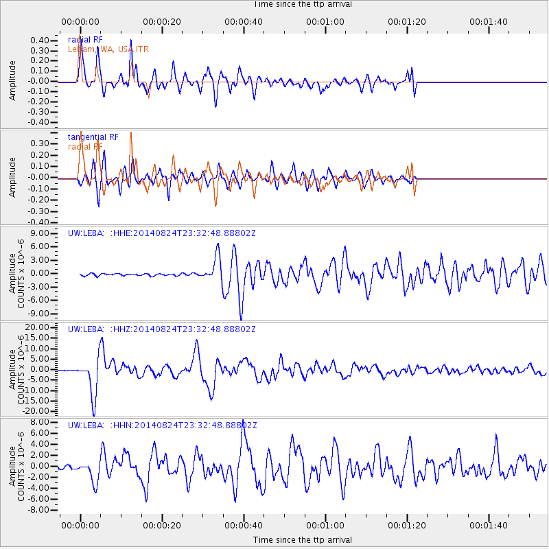
Signal To Noise
| Channel | StoN | STA | LTA |
| UW:LEBA: :HHZ:20140824T23:32:48.88802Z | 53.253605 | 9.25858E-6 | 1.7385827E-7 |
| UW:LEBA: :HHN:20140824T23:32:48.88802Z | 12.069428 | 2.0029418E-6 | 1.6595166E-7 |
| UW:LEBA: :HHE:20140824T23:32:48.88802Z | 12.533721 | 2.8249158E-6 | 2.2538524E-7 |
| Arrivals |
| Ps | 4.3 SECOND |
| PpPs | 12 SECOND |
| PsPs/PpSs | 17 SECOND |


