You are here: Home > Network List > WI - West Indies IPGP Network Stations List
> Station MAGL Barre de l'ile, Saint louis, Marie Galante > Earthquake Result Viewer
MAGL Barre de l'ile, Saint louis, Marie Galante - Earthquake Result Viewer
| Earthquake location: |
Central Peru |
| Earthquake latitude/longitude: |
-14.6/-73.6 |
| Earthquake time(UTC): |
2014/08/24 (236) 23:21:45 GMT |
| Earthquake Depth: |
101 km |
| Earthquake Magnitude: |
6.9 MWW, 6.8 MI, 6.9 MWB |
| Earthquake Catalog/Contributor: |
NEIC PDE/NEIC COMCAT |
|
| Network: |
WI West Indies IPGP Network |
| Station: |
MAGL Barre de l'ile, Saint louis, Marie Galante |
| Lat/Lon: |
15.95 N/61.28 W |
| Elevation: |
150 m |
|
| Distance: |
32.7 deg |
| Az: |
22.295 deg |
| Baz: |
202.446 deg |
| Ray Param: |
0.078269035 |
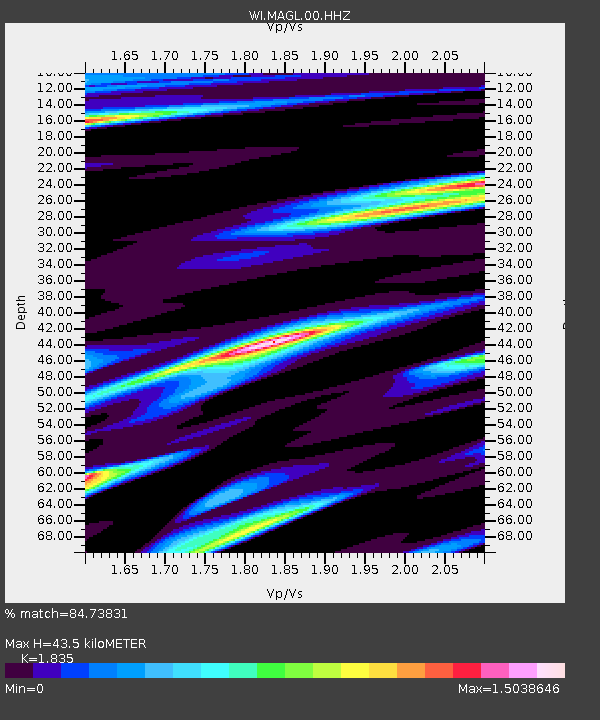
| Estimated Moho Depth: |
43.5 km |
| Estimated Crust Vp/Vs: |
1.84 |
| Assumed Crust Vp: |
5.88 km/s |
| Estimated Crust Vs: |
3.205 km/s |
| Estimated Crust Poisson's Ratio: |
0.29 |
|
| Radial Match: |
84.73831 % |
| Radial Bump: |
394 |
| Transverse Match: |
66.85258 % |
| Transverse Bump: |
400 |
| SOD ConfigId: |
769524 |
| Insert Time: |
2014-09-08 00:15:28.760 +0000 |
| GWidth: |
2.5 |
| Max Bumps: |
400 |
| Tol: |
0.001 |
|
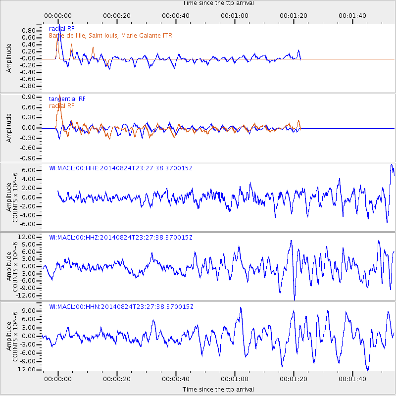
Signal To Noise
| Channel | StoN | STA | LTA |
| WI:MAGL:00:HHZ:20140824T23:27:38.370015Z | 3.4101264 | 1.6773175E-6 | 4.918638E-7 |
| WI:MAGL:00:HHN:20140824T23:27:38.370015Z | 3.0771132 | 1.4697449E-6 | 4.7763757E-7 |
| WI:MAGL:00:HHE:20140824T23:27:38.370015Z | 1.9145076 | 1.0528132E-6 | 5.499133E-7 |
| Arrivals |
| Ps | 6.6 SECOND |
| PpPs | 20 SECOND |
| PsPs/PpSs | 26 SECOND |


