You are here: Home > Network List > WY - Yellowstone Wyoming Seismic Network Stations List
> Station YTP The Promontory, YNP, WY, USA > Earthquake Result Viewer
YTP The Promontory, YNP, WY, USA - Earthquake Result Viewer
| Earthquake location: |
Central Peru |
| Earthquake latitude/longitude: |
-14.6/-73.6 |
| Earthquake time(UTC): |
2014/08/24 (236) 23:21:45 GMT |
| Earthquake Depth: |
101 km |
| Earthquake Magnitude: |
6.9 MWW, 6.8 MI, 6.9 MWB |
| Earthquake Catalog/Contributor: |
NEIC PDE/NEIC COMCAT |
|
| Network: |
WY Yellowstone Wyoming Seismic Network |
| Station: |
YTP The Promontory, YNP, WY, USA |
| Lat/Lon: |
44.39 N/110.29 W |
| Elevation: |
2384 m |
|
| Distance: |
67.5 deg |
| Az: |
332.375 deg |
| Baz: |
141.23 deg |
| Ray Param: |
0.056629594 |
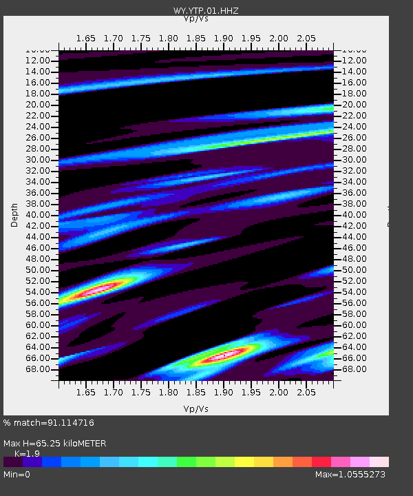
| Estimated Moho Depth: |
65.25 km |
| Estimated Crust Vp/Vs: |
1.90 |
| Assumed Crust Vp: |
6.35 km/s |
| Estimated Crust Vs: |
3.342 km/s |
| Estimated Crust Poisson's Ratio: |
0.31 |
|
| Radial Match: |
91.114716 % |
| Radial Bump: |
326 |
| Transverse Match: |
81.20746 % |
| Transverse Bump: |
400 |
| SOD ConfigId: |
769524 |
| Insert Time: |
2014-09-08 00:17:12.327 +0000 |
| GWidth: |
2.5 |
| Max Bumps: |
400 |
| Tol: |
0.001 |
|

Signal To Noise
| Channel | StoN | STA | LTA |
| WY:YTP:01:HHZ:20140824T23:32:00.64803Z | 86.7241 | 2.459807E-7 | 2.836359E-9 |
| WY:YTP:01:HHN:20140824T23:32:00.64803Z | 26.779356 | 9.749064E-8 | 3.6405148E-9 |
| WY:YTP:01:HHE:20140824T23:32:00.64803Z | 22.373144 | 9.229753E-8 | 4.1253716E-9 |
| Arrivals |
| Ps | 9.6 SECOND |
| PpPs | 29 SECOND |
| PsPs/PpSs | 38 SECOND |


