You are here: Home > Network List > PY - PFO Array Stations List
> Station BPH13 Pinon Flat Observatory, CA, USA > Earthquake Result Viewer
BPH13 Pinon Flat Observatory, CA, USA - Earthquake Result Viewer
| Earthquake location: |
Central Peru |
| Earthquake latitude/longitude: |
-14.6/-73.6 |
| Earthquake time(UTC): |
2014/08/24 (236) 23:21:45 GMT |
| Earthquake Depth: |
101 km |
| Earthquake Magnitude: |
6.9 MWW, 6.8 MI, 6.9 MWB |
| Earthquake Catalog/Contributor: |
NEIC PDE/NEIC COMCAT |
|
| Network: |
PY PFO Array |
| Station: |
BPH13 Pinon Flat Observatory, CA, USA |
| Lat/Lon: |
33.61 N/116.46 W |
| Elevation: |
1300 m |
|
| Distance: |
63.0 deg |
| Az: |
320.399 deg |
| Baz: |
132.31 deg |
| Ray Param: |
0.05959441 |
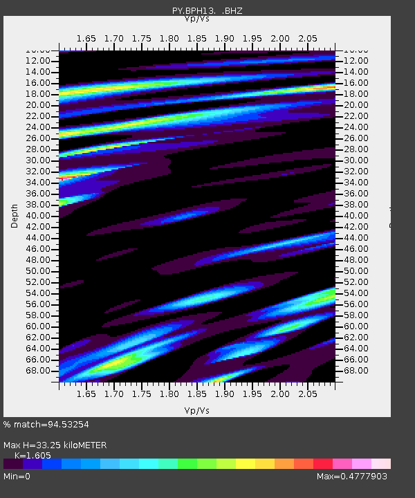
| Estimated Moho Depth: |
33.25 km |
| Estimated Crust Vp/Vs: |
1.61 |
| Assumed Crust Vp: |
6.264 km/s |
| Estimated Crust Vs: |
3.903 km/s |
| Estimated Crust Poisson's Ratio: |
0.18 |
|
| Radial Match: |
94.53254 % |
| Radial Bump: |
400 |
| Transverse Match: |
89.19155 % |
| Transverse Bump: |
400 |
| SOD ConfigId: |
769524 |
| Insert Time: |
2014-09-08 00:19:09.307 +0000 |
| GWidth: |
2.5 |
| Max Bumps: |
400 |
| Tol: |
0.001 |
|

Signal To Noise
| Channel | StoN | STA | LTA |
| PY:BPH13: :BHZ:20140824T23:31:31.324971Z | 24.833256 | 5.52242E-6 | 2.2238004E-7 |
| PY:BPH13: :BHN:20140824T23:31:31.324971Z | 7.8676476 | 1.5162027E-6 | 1.927136E-7 |
| PY:BPH13: :BHE:20140824T23:31:31.324971Z | 23.868114 | 2.2044405E-6 | 9.235922E-8 |
| Arrivals |
| Ps | 3.4 SECOND |
| PpPs | 13 SECOND |
| PsPs/PpSs | 17 SECOND |


