You are here: Home > Network List > TA - USArray Transportable Network (new EarthScope stations) Stations List
> Station Z41A Richland Creek Farm, El Dorado, AR, USA > Earthquake Result Viewer
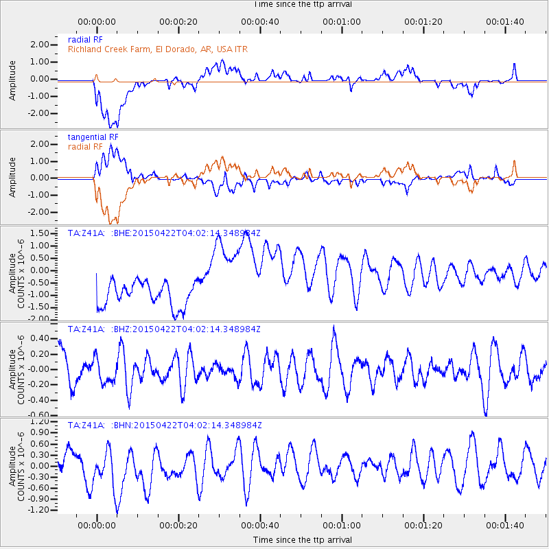
Z41A Richland Creek Farm, El Dorado, AR, USA - Earthquake Result Viewer
*The percent match for this event was below the threshold and hence no stack was calculated.
| Earthquake location: |
Kuril Islands |
| Earthquake latitude/longitude: |
46.3/153.0 |
| Earthquake time(UTC): |
2015/04/22 (112) 03:50:34 GMT |
| Earthquake Depth: |
40 km |
| Earthquake Magnitude: |
4.3 mb, 4.1 MS |
| Earthquake Catalog/Contributor: |
ISC/ISC |
|
| Network: |
TA USArray Transportable Network (new EarthScope stations) |
| Station: |
Z41A Richland Creek Farm, El Dorado, AR, USA |
| Lat/Lon: |
33.26 N/92.80 W |
| Elevation: |
62 m |
|
| Distance: |
81.1 deg |
| Az: |
50.658 deg |
| Baz: |
320.205 deg |
| Ray Param: |
$rayparam |
*The percent match for this event was below the threshold and hence was not used in the summary stack. |
|
| Radial Match: |
44.782692 % |
| Radial Bump: |
400 |
| Transverse Match: |
56.662945 % |
| Transverse Bump: |
400 |
| SOD ConfigId: |
7422571 |
| Insert Time: |
2019-04-18 07:43:42.310 +0000 |
| GWidth: |
2.5 |
| Max Bumps: |
400 |
| Tol: |
0.001 |
|
Signal To Noise
| Channel | StoN | STA | LTA |
| TA:Z41A: :BHZ:20150422T04:02:14.348984Z | 0.7238395 | 1.6013587E-7 | 2.2123118E-7 |
| TA:Z41A: :BHN:20150422T04:02:14.348984Z | 2.3005495 | 5.9564553E-7 | 2.5891447E-7 |
| TA:Z41A: :BHE:20150422T04:02:14.348984Z | 3.6590357 | 1.7752686E-6 | 4.851739E-7 |
| Arrivals |
| Ps | |
| PpPs | |
| PsPs/PpSs | |


