You are here: Home > Network List > TA - USArray Transportable Network (new EarthScope stations) Stations List
> Station H63A New Sharon, ME, USA > Earthquake Result Viewer
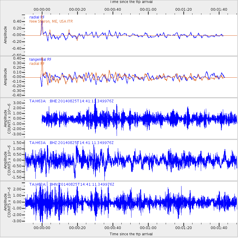
H63A New Sharon, ME, USA - Earthquake Result Viewer
*The percent match for this event was below the threshold and hence no stack was calculated.
| Earthquake location: |
Near Coast Of Peru |
| Earthquake latitude/longitude: |
-16.2/-73.2 |
| Earthquake time(UTC): |
2014/08/25 (237) 14:31:37 GMT |
| Earthquake Depth: |
58 km |
| Earthquake Magnitude: |
5.6 M |
| Earthquake Catalog/Contributor: |
NEIC PDE/NEIC ALERT |
|
| Network: |
TA USArray Transportable Network (new EarthScope stations) |
| Station: |
H63A New Sharon, ME, USA |
| Lat/Lon: |
44.66 N/70.04 W |
| Elevation: |
109 m |
|
| Distance: |
60.6 deg |
| Az: |
2.626 deg |
| Baz: |
183.537 deg |
| Ray Param: |
$rayparam |
*The percent match for this event was below the threshold and hence was not used in the summary stack. |
|
| Radial Match: |
60.324432 % |
| Radial Bump: |
400 |
| Transverse Match: |
45.397453 % |
| Transverse Bump: |
400 |
| SOD ConfigId: |
769524 |
| Insert Time: |
2014-09-08 15:02:25.063 +0000 |
| GWidth: |
2.5 |
| Max Bumps: |
400 |
| Tol: |
0.001 |
|
Signal To Noise
| Channel | StoN | STA | LTA |
| TA:H63A: :BHZ:20140825T14:41:11.349976Z | 1.746285 | 5.7692375E-7 | 3.3037205E-7 |
| TA:H63A: :BHN:20140825T14:41:11.349976Z | 2.004655 | 1.4508664E-6 | 7.2374877E-7 |
| TA:H63A: :BHE:20140825T14:41:11.349976Z | 1.8011265 | 1.1777806E-6 | 6.539134E-7 |
| Arrivals |
| Ps | |
| PpPs | |
| PsPs/PpSs | |


