You are here: Home > Network List > TA - USArray Transportable Network (new EarthScope stations) Stations List
> Station Y57A Sumter, SC, USA > Earthquake Result Viewer
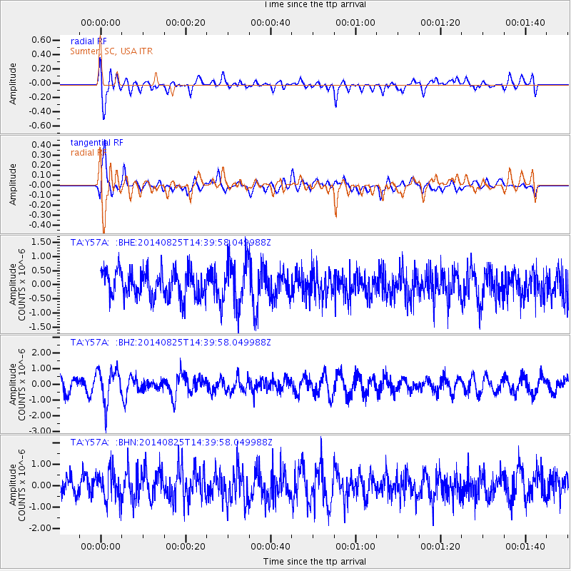
Y57A Sumter, SC, USA - Earthquake Result Viewer
*The percent match for this event was below the threshold and hence no stack was calculated.
| Earthquake location: |
Near Coast Of Peru |
| Earthquake latitude/longitude: |
-16.2/-73.2 |
| Earthquake time(UTC): |
2014/08/25 (237) 14:31:37 GMT |
| Earthquake Depth: |
58 km |
| Earthquake Magnitude: |
5.6 M |
| Earthquake Catalog/Contributor: |
NEIC PDE/NEIC ALERT |
|
| Network: |
TA USArray Transportable Network (new EarthScope stations) |
| Station: |
Y57A Sumter, SC, USA |
| Lat/Lon: |
34.02 N/80.39 W |
| Elevation: |
56 m |
|
| Distance: |
50.4 deg |
| Az: |
352.292 deg |
| Baz: |
171.075 deg |
| Ray Param: |
$rayparam |
*The percent match for this event was below the threshold and hence was not used in the summary stack. |
|
| Radial Match: |
59.124004 % |
| Radial Bump: |
400 |
| Transverse Match: |
65.8546 % |
| Transverse Bump: |
400 |
| SOD ConfigId: |
769524 |
| Insert Time: |
2014-09-08 15:06:12.684 +0000 |
| GWidth: |
2.5 |
| Max Bumps: |
400 |
| Tol: |
0.001 |
|
Signal To Noise
| Channel | StoN | STA | LTA |
| TA:Y57A: :BHZ:20140825T14:39:58.049988Z | 2.248361 | 1.0845328E-6 | 4.8236586E-7 |
| TA:Y57A: :BHN:20140825T14:39:58.049988Z | 1.4955987 | 7.221175E-7 | 4.8282834E-7 |
| TA:Y57A: :BHE:20140825T14:39:58.049988Z | 1.7036908 | 8.0734276E-7 | 4.738787E-7 |
| Arrivals |
| Ps | |
| PpPs | |
| PsPs/PpSs | |


